Explorer
Log in

Visite audio autonome de l'Ultimate Utah Bundle

Aperçu
Recommended: Purchase one tour per car, not per person. Everyone listens together!

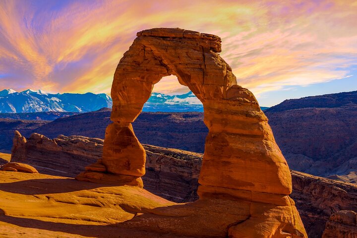
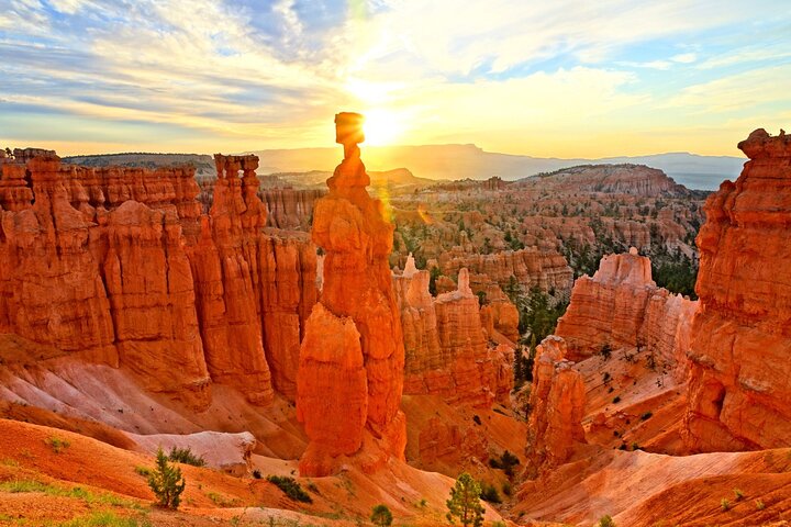
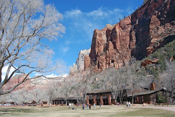
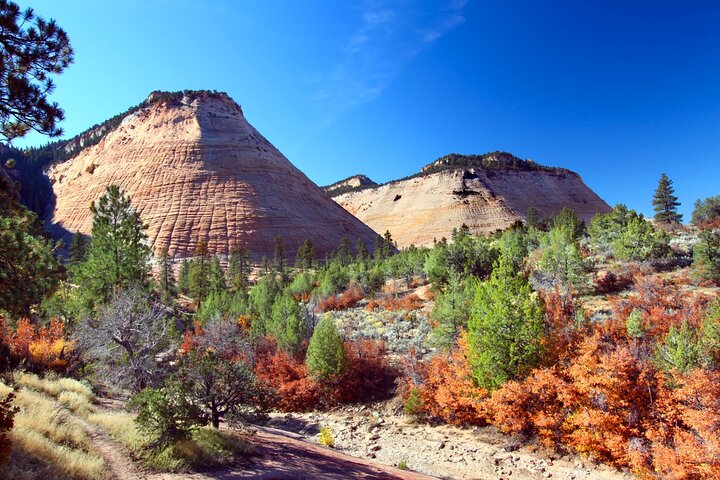
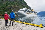
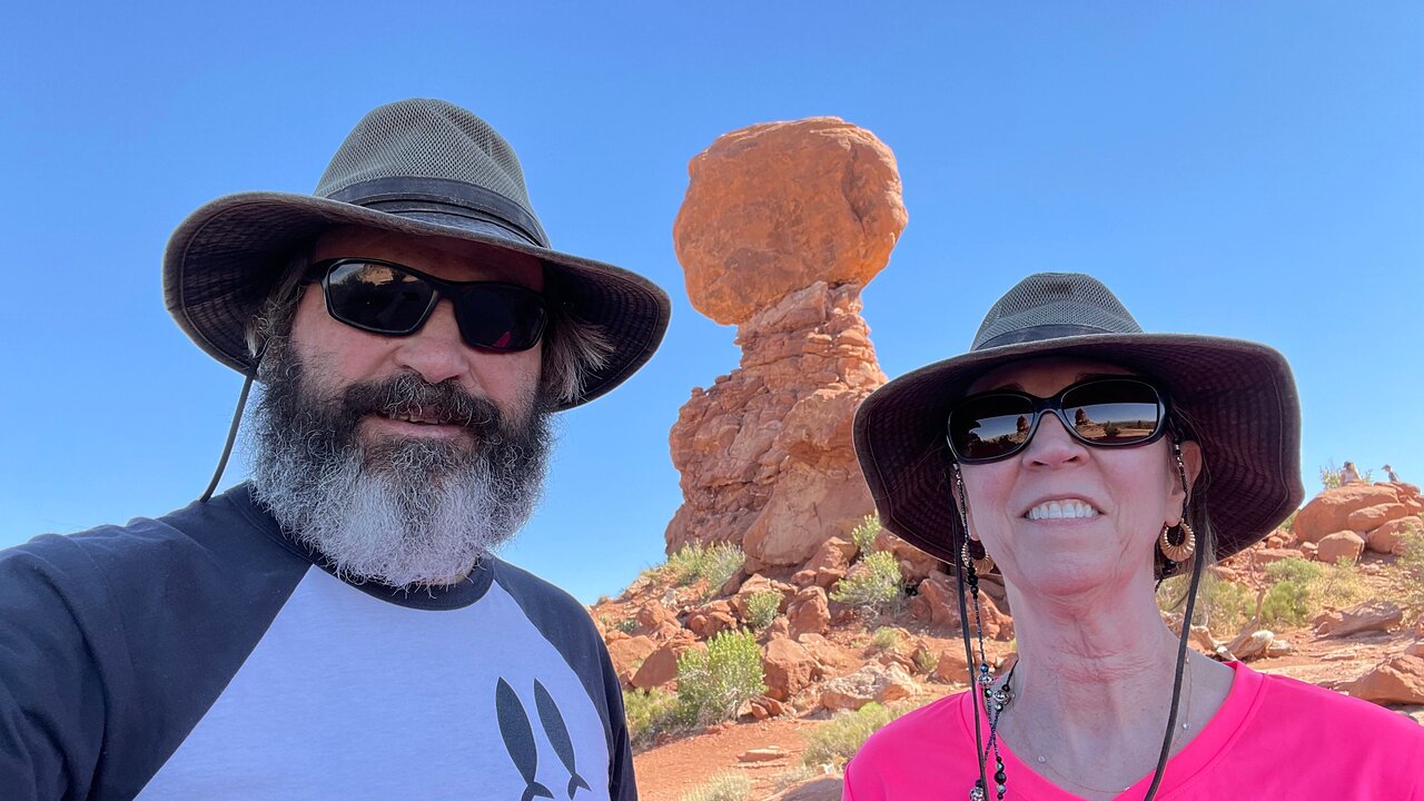
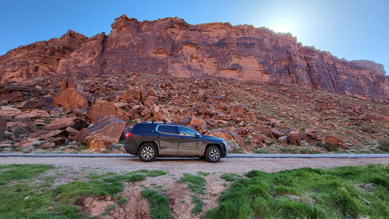
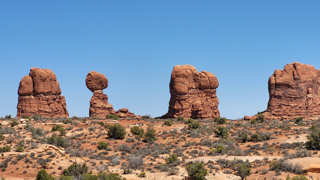
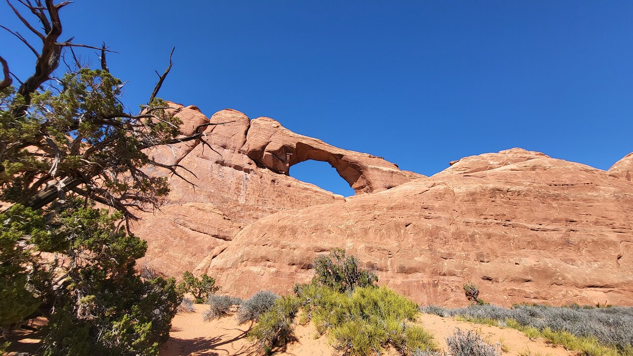
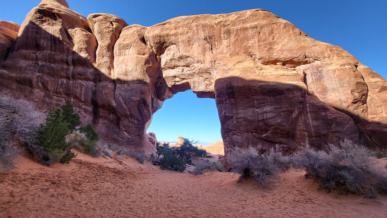
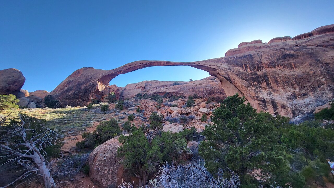
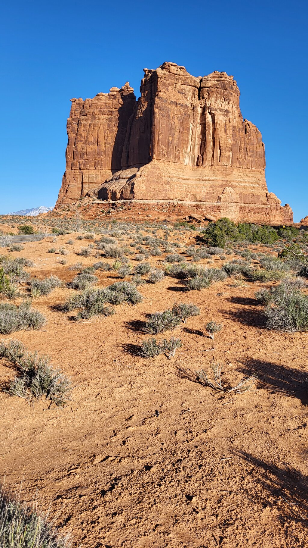
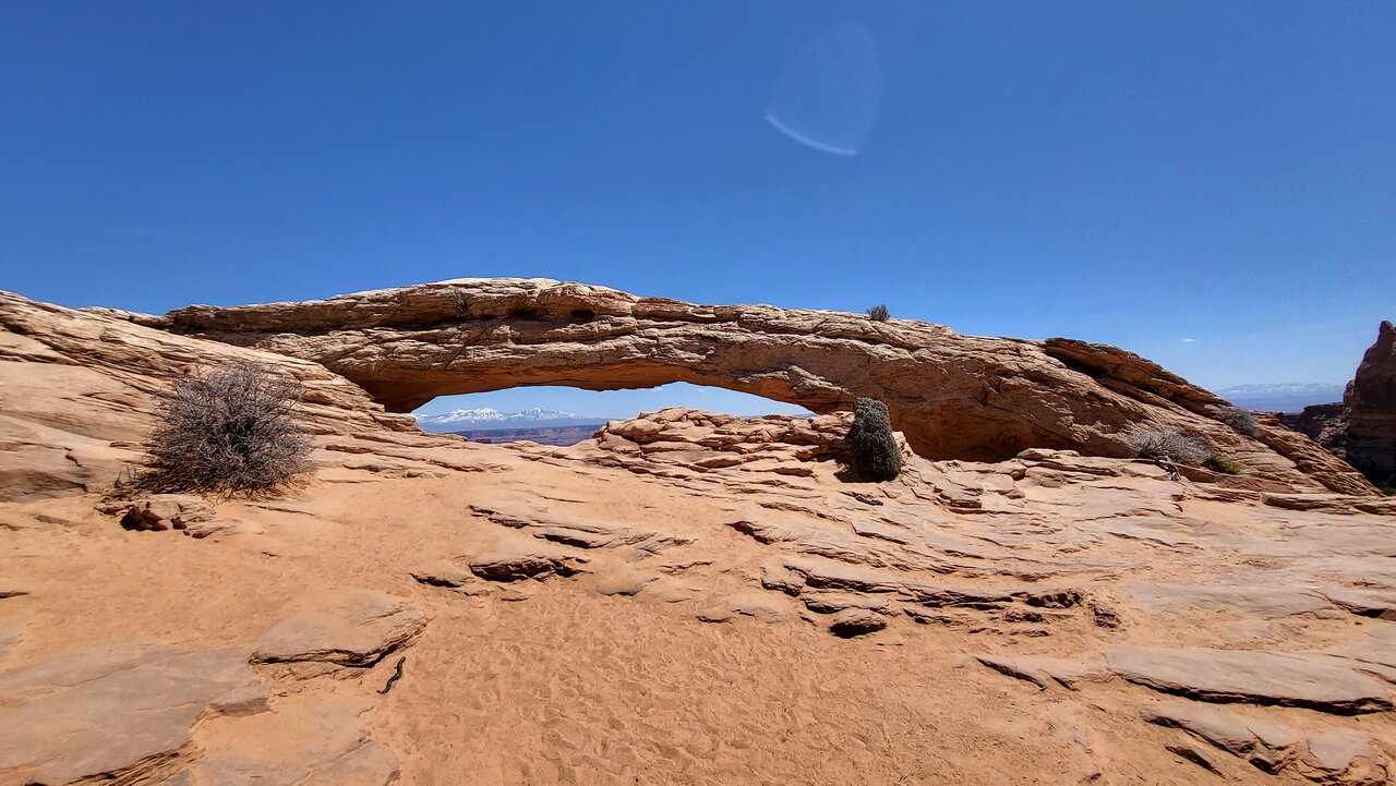
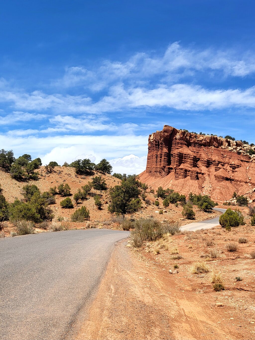
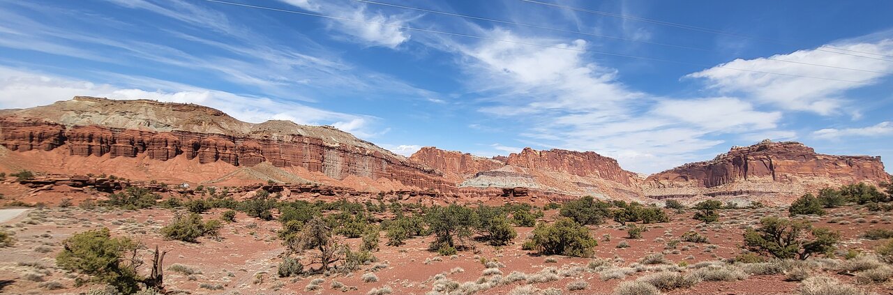
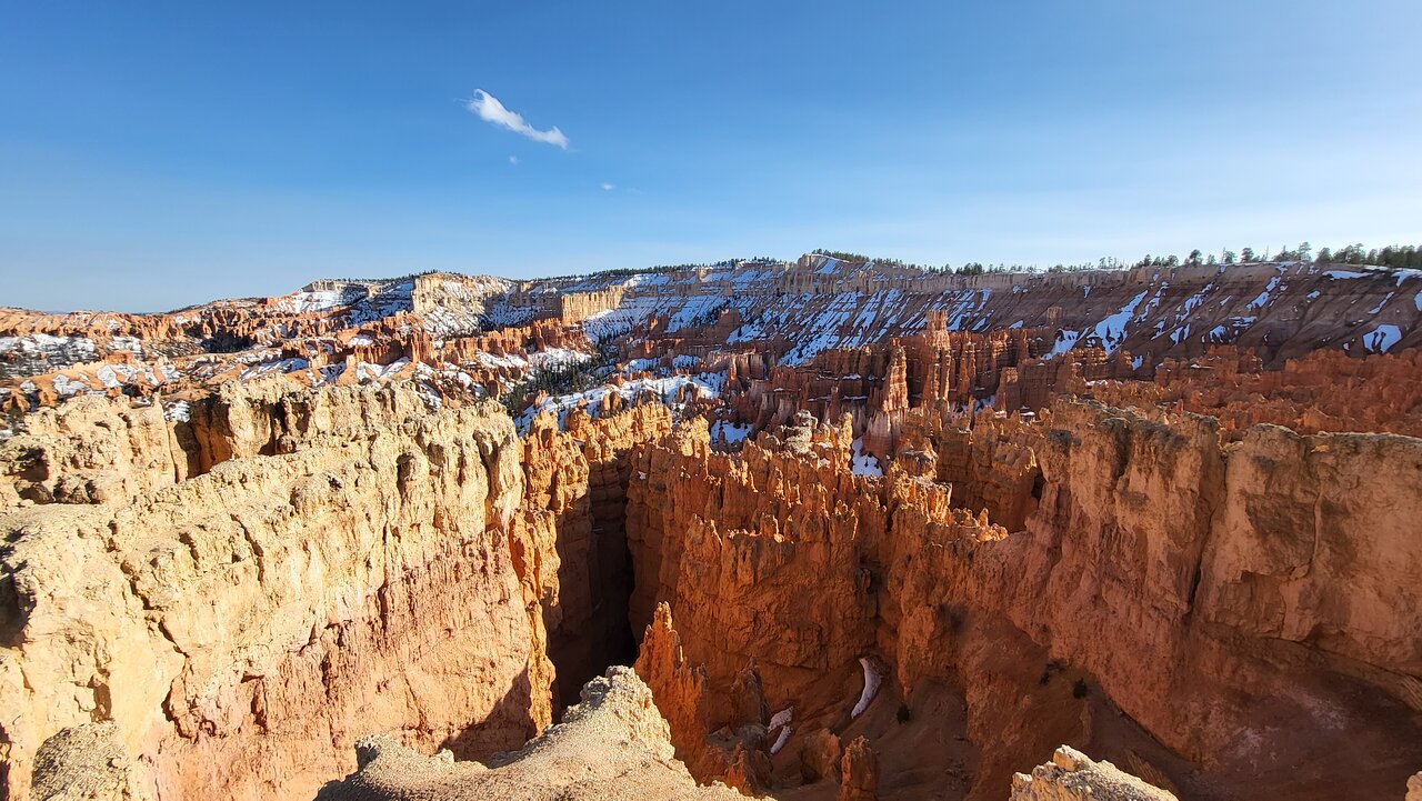
Explore all of Utah's majestic beauty! From the towering canyons of Zion to the precarious arches of Arches -- see everything the national parks have to offer, and more. Meander through Bryce's mysterious hoodoos, marvel at the vastness of the Grand Staircase, and oogle the huge formations of Monument Valley. This combo tour contains the driving tours for Arches, Canyonlands, Monument Valley, Bryce, Grand Staircase - Escalante, and Zion all in one.

After booking, check your email to download the separate Audio Tour Guide App by Action, enter your unique password, and access your tour. These steps require good internet/Wi-Fi access. From there, follow the audio instructions and the route.

Buy once, use for one year! Ideal for extended visits and return trips over the next 12 months.

This isn't an entrance ticket. Check opening hours before your visit.
Ville: Parc national de Zion
Sun 22 Jun
i
Vous pouvez déjà choisir la date sur le site de réservation
À partir de $49.99
Sun 22 Jun
À partir de $49.99
Faire une réservation
Ce qui est inclu
Offline use: No cell signal or wifi required. Offline GPS Map & route. Stop-to-stop direction.
Private tour in your/rental car: No group. Take breaks for photos/ snacks/hikes. Go at your own pace
Don’t miss a thing: Full itinerary, travel tips, professionally narrated hidden stories, video, text
Flexible schedule: Use any day, any time. Travel over multiple days or on next trip. Never expires.
Good value: Buy just one per car. Don’t pay for each person. Save money compared to a bus tour.
App on your phone: A link to download the Action Guide app. Password for your tours. Preview at home
Easy to use: Stories play automatically by GPS. Hands-free. Get HELP all day: Call, Chat or Email.
Information additionnelle
  • Public transportation options are available nearby
  • Suitable for all physical fitness levels
  • How to access: Once you book a tour, you’ll get a confirmation email and text with instructions: • Download the separate tour app by Action • Enter the password • Download the tour MUST DO while in strong wifi/cellular Works offline after download
  • How to start touring: Open Action’s separate audio tour guide app once onsite. • If there is just one tour, launch it. • If multiple tour versions exist, launch the one with your planned starting point and direction.
  • Go to the starting point No one will meet you at the start. This tour is self-guided Enter the first story’s point and the audio will begin automatically Follow the audio cues to the next story, which will also play automatically. Enjoy hands-free exploring. If you face audio issues, contact support. Stick to the tour route & speed limit for the best experience.
  • Travel worry-free: Use the tour app anytime, on any day, and over multiple days. Start and pause the tour whenever you like, taking breaks and exploring side excursions at your own pace. Skip anything you don’t care about or explore bonus content for everything that interests you
  • Savings tips: Driving tours: purchase just one tour for everyone in the car
  • Buy once, use for one year! Ideal for extended visits and return trips over the next 12 months.
À quoi s'attendre
1
Arches Visitor Center
Our adventure into the astounding Arches begins just before the park's entrance and visitor center. We're about to see stunning natural monuments, unlikely rock formations, and alien, ancient landscapes.
2
Delicate Arch
Now we're at THE most famous spot in Arches: Delicate Arch. A quick hike brings us right up to this gorgeous - and improbable - formation.
3
Fiery Furnace
Our drive continues past the Fiery Furnace: a network of narrow canyons & passages amid towering red cliffs at Arches National Park.
4
Sand Dune Arch
As we drive, exploring more arches, we'll learn more about the Paiute myths behind them, the Spanish and Mormon settlers who tried to survive in this land, and the people who were able to preserve this stunning landscape as a national park.
5
Bryce Canyon Visitor Center
Embark on this epic adventure through Bryce Canyon National Park just before the Visitor Center. As we begin the drive, we'll learn about how the canyon got its namesake and about the original Paiute people who called this land home.
6
Fairyland Point
Our first detour is at the breathtaking Fairyland Point. This overlook offers a great sneak peek at everything Bryce Canyon contains: sweeping vistas, sheer cliffs, and, of course, the world-famous hoodoos!
7
Sunrise Point
Our next stop is one of the most famous in the entire park: Sunrise Point. From this vantage point, we'll see unique, picturesque rock formations spread out in front of us and a plethora of natural trails leading into the vast, alient landscape.
8
Sunset Point
Our drive brings us to another striking vista point overlooking the Bryce Amphitheatre: Sunset Point. Here, as we gaze out over the implausible shapes below us, we'll learn about the science behind their formations and understand what, exactly, makes a hoodoo. We'll explore the impact of geology and erosion over a monumental time scale, hoping to understand how such an incredible landscape came into existence.
9
Inspiration Point
We continue our self-guided tour deeper into Bryce Canyon, towards Inspiration Point. As we drive, we learn about the Paiute people and their mythologies. They had their own explanation for the uniqueness of this landscape and the origins of Bryce's famous hoodoos.
10
Bryce Point
This brings us to Bryce Point, which offers one of the most scenic vistas of the full amphitheater. Bryce Point is also famous for its extraordinary sunrises. From here you can watch the tops of hoodoos set alight as if by fire from the first rays of the rising sun. Like fire, the orange light quickly spreads driving shadows from all but the deepest recesses of the amphitheater. As we drive here, we'll learn about the Mormon settlers who followed the Paiute and tried to eke out a living in this unforgiving climate.
11
Paria View
Our self-guided tour continues to Paria View, where we see the effects of a centuries-old glacier. As the earth warmed about 12,000 years ago, the last ice age came to an end. As the enormous glaciers which covered the American continent melted, all that new water had to go somewhere. Answer: down the canyon!
12
Farview Point
Our next stop is at Farview Point. It’s not just the elevation that allows for such incredible views here -- the land here also offers something becoming increasingly rare in today’s world. Can you guess what it is? Clean air! That's helped along by the abundance of bristlecone pines here, which are the Earth's oldest trees.
13
Natural Bridge
The self-guided tour passes by Natural Bridge next, which features unusual arches and formations -- in case we weren't already amazed by the hoodoos of the amphitheater!
14
Agua Canyon
At Agua Canyon two prominent hoodoos command attention. On the left, is the taller of the two towers, "The Hunter." To the right, the "Rabbit". Neither looks anything like a hunter or rabbit though! As we drive on, we'll learn about rabbits, deer, and other wildlife of Bryce. We'll also understand what tricks they use to survive the scorching hot summers and deeply freezing winters.
15
Ponderosa Canyon
This brings us to Ponderosa Point, from which you can see the park’s iconic junipers sprawling out into the distance. We're now driving into the deepest recesses of Bryce Canyon National Park.
16
Rainbow Point
Finally, we reach the farthest overlooks inside Bryce Canyon: Rainbow and Yovimpa. From here, you can see nearly everything in Bryce Canyon -- the quintessential hoodoos, the verdant basin, the sheer cliffs. You can even see that you're on the top step of the incredibly massive "Grand Staircase" -- a geologic structure "stepping down" all the way to the Grand Canyon in Arizona.
17
Red Canyon Visitor Center
This unique Visitor Center is perched high upon the rocky cliffs of Flaming Gorge and offers visitors a commanding view of the vast Red Canyon, carved by the Green River many eons ago. It is open daily from mid-May through mid-September. One can gain a good sense of the area’s frontier history and watchable wildlife through exhibits in the Center.
18
Bryce Canyon National Park
Bryce Canyon National Park, a sprawling reserve in southern Utah, is known for crimson-colored hoodoos, which are spire-shaped rock formations. The park’s main road leads past the expansive Bryce Amphitheater, a hoodoo-filled depression lying below the Rim Trail hiking path. It has overlooks at Sunrise Point, Sunset Point, Inspiration Point and Bryce Point. Prime viewing times are around sunup and sundown.
19
Escalante Petrified Forest State Park
The Escalante Petrified Forest is another geological time machine. The trees have long since turned to stone, and their ancient, multi-colored bark offers clues to the landscape’s distant past.
20
Escalante Interagency Visitor Center
The Escalante Interagency Visitor Center Focuses on the ecology of the 1.9-million-acre Grand Staircase-Escalante National Monument. The center provides information for enjoying and exploring the Monument, Dixie National Forest, and Glen Canyon National Recreation Area. It was opened to the public in 2005 and is one of the Department of Interior's first Gold LEED-rated facilities.
21
Spooky Gulch
Spooky Gulch is particularly narrow and winding, and if you’re able to make the squeeze, hiking through the gulch can be quite the experience. You won’t need any special hiking gear or experience-- just an extra hour to drive there and another hour or two to explore.
22
Lower Calf Creek Falls
Calf Creek Falls is a perennial waterfall in the Grand Staircase-Escalante National Monument in Utah that totals 214 feet. The lower tier is a 126-foot cascade and is very popular because it can be reached by an easy hike on a 5½ mile roundtrip trail.
23
The Hogback
This winding stretch of road is famous for its sharp curves, steep drops, and spectacular views on either side. The 600-foot drops on either side of the road create the feeling of driving on a raised spine... which is how the road gets its name!
24
Upper Calf Creek Falls
Upper Calf Creek Falls was a little known 88ft waterfall that was further upstream from the wildly popular Lower Calf Creek Falls.
25
Boulder
Boulder is a town in Garfield County, Utah, United States, 27 miles northeast of Escalante on Utah Scenic Byway 12 at its intersection with the Burr Trail. As of the 2010 census, the town population was 226, a modest increase over the 2000 figure of 180.
26
Capitol Reef National Park
Capitol Reef National Park is in Utah's south-central desert. It surrounds a long wrinkle in the earth known as the Waterpocket Fold, with layers of golden sandstone, canyons and striking rock formations. Among the park's sights are the Chimney Rock pillar, the Hickman Bridge arch, and Capitol Reef, known for its white sandstone domes. In the north are the towering monoliths of Cathedral Valley.
27
Forrest Gump Point
Our tour of Monument Valley actually begins a little outside the valley: Forest Gump Point. The crest of this hill offers a fantastic panorama of Monument Valley... made famous by the movie!
28
Wildcat Trail
We'll hit our first detour at Wildcat Trail, where you can hop out walk into the valley itself.
29
John Ford’s Point
As we follow the trail deeper into Monument Valley, we'll learn more about the Navajo, the mythical buried silver, and their struggle to defend their land against the ever-encroaching colonists. We'll learn about the Long March of the Navajo, the Navajo Code Talkers of WWII, and the Navajo families on the reservation land today. We'll also explore the depiction of the Navajo in Western movies -- specifically in John Ford's Hollywood.
30
Artist’s Point
As we learn, we're also driving. The tour brings us next to Artist's Point. This overlook, unsurprisingly, is famously popular among painters and illustrators. Countless artists have set up canvasses here and recreated this stunning landscape with paint and brush.
31
North Window Overlook
Our drive continues towards the North Window Overlook, a picture-perfect spot for the sunrise. Those morning rays illuminating the buttes and spires of Monument Valley aren’t something you’ll soon forget! Even if you're here after sunrise, the vistas are unparalleled.
32
Camel Butte
Finally, we're at the last incredible vista of the tour: Camel Butte and Elephant Butte. Camel Butte might not look especially like a camel, but when you’re naming rocks you have to get creative! Camel Butte almost hits 1,000 feet but pales in comparison to its sibling, Elephant Butte, stretching over 1,000 feet high. Now that might be impressive on its own, but remember that you’re on a plateau right now which is already raised around 5,000 feet. That means the peak of Elephant Butte is more than 6,000 feet above sea level!
33
Springdale Visitor Center
Welcome to Zion National Park! This raw landscape has it all: staggering mountain peaks, stunning natural pools, and gorgeous vistas. We’ll explore it all today.
34
Zion Canyon Visitor Center
Continue straight. Just before the bridge, you’ll see a path on the left. That’s the start of the Pa’rus Trail. And just after the bridge is another path -- the Watchman Trail. Both are popular hikes with great views at the end.
35
Zion Human History Museum
While we don’t know too much about those Ice Age hunters, newer residents left their stories behind. Around 300 BCE, people started settling down here and farming. They grew squash and corn and gradually learned how to better cultivate the land and survive the unforgiving climate. One group, the Fremont, cultivated a drought- and cold-resistant species of corn that could thrive even at high altitudes.
36
Court of the Patriarchs
"Whew, what a view! Those three mountains are the iconic Court of the Patriarchs. And who are these patriarchs? Well, a local Christian minister named them after three figures from the Bible: Abraham, Isaac, and Jacob, from left to right. "
37
Emerald Pools
"First, bring lots of water! You may think you’ve got enough… but you probably don’t. This might seem obvious, but Utah’s heat is unforgiving, and heat-stroke or sun-stroke can easily ruin a fun vacation. Second, make sure you don’t overtax yourself! Hiking around here is going to be more difficult than you might be used to, thanks to the elevation. Be sure you don’t embark on journeys you’re not certain you’ll be able to finish."
38
Angel's Landing
This park has a ton of great trails, but Angel’s Landing stands in a league of its own. Those who complete the hike describe it as a breathtaking experience like no other, offering impossible views and a major adrenaline rush.
39
East Temple
That towering summit ahead is the East Temple, standing at 1,700 feet. Notice how the cliff isn’t all one color? You’ve probably seen this on the other rock faces as well. That’s because these cliffs are actually made of rock from a bunch of different eras in the earth’s history.
40
Canyon Overlook Trail
The Canyon Overlook Trail is one of East Zion’s finest -- even though it’s short and easy. Why? Simple -- the spectacular views from the top.
41
Checkerboard Mesa
Look at that mesa rising into the sky. Notice anything peculiar? As you get closer, you should be able to make out a strange grid of criss-crossed lines all over it. It looks a bit like a checkerboard, which is how it gets the name Checkerboard Mesa!
42
Monitor and Merriamac Rock Formations
Look to the right. All you can see at the moment are tall rock walls. That’s because we’re near the floor of Sevenmile Canyon. As we continue to drive, we’ll emerge from the canyon and be able to see two very distinct features in the distance to the right -- the Merrimac and the Monitor.
43
Dead Horse Point State Park
Dead Horse Point — it’s a creepy name, isn’t it? According to local legend, wild mustangs used to be corralled here to be broken in the early 1800s. Once all the desirable horses had been broken and claimed by the cowboys, the undesirables were left to go free.
44
Island In The Sky Visitor Center
Stop by the Visitor Center coming up ahead. It’s a great place to grab supplies, use the bathroom, and fill up your water bottles. As you’ve already seen, this park doesn’t have much infrastructure, and being dehydrated out here is no joke.
45
Shafer Canyon Overlook
This overlook offers views from three sides. It may be a bit daunting if you're afraid of heights since there’s nothing between you and the Canyon. However, the incredible view is worth it.
46
Grand View Point Overlook
We’re now at the end of the Canyonlands National Park tour. I hope you’ve enjoyed the journey! If you enjoyed the tour, check out our other tours of nearby Arches, Bryce, Zion, and more!
47
Lathrop Canyon
A lot of natural landmarks and trails in Canyonlands are named by or after cowboys and ranchers. In fact, Ned Chaffin’s father and one of his brothers had a spring named after them.
48
Mesa Arch
Ahead, pull over for Mesa Arch. This is a must-do at Canyonlands. Once you’ve parked, walk along the short trail to the arch. As you walk, notice the juniper and pinyon trees around you. These are popular in Canyonlands so keep an eye out for them elsewhere too.
49
Green River Overlook
The Green River Overlook offers some of the most unique views of Canyonland’s Island in the Sky District. You’re able to see the Green River continuing its work on the canyon walls. The river is the largest stream in Utah at 730 miles. The name probably comes from the green soapstone that can be found along its banks.
50
Aztec Butte Trail
What makes this trail special? Simple: the granaries left here by Native peoples. They’re visible from the base of the last hill if you just keep your eyes open. These granaries are hundreds of years old, so be careful when approaching.
51
Whale Rock
In front of you is perhaps the world’s largest whale. Don’t see it? The whale’s head is on the left side of the rock. There’s an easy one-mile hike that takes you up along the whale’s back. When you get on top of this cetacean, you’ll be rewarded with spectacular views of the Upheaval Dome.
52
Upheaval Dome
Remember how the park’s rocks have been formed in layers? In most of the park, these layers haven’t been disrupted since their formation. What you see is what was deposited, all those hundreds of millions of years ago.
53
Candlestick Tower Overlook
In the distance, do you see three giant candles sticking out of the landscape? That’s Candlestick Tower! Doesn’t this sandstone formation look like a layered birthday cake, topped with candles? * The bottom layer is white, the middle a reddish-brown, and the top is red.
54
Murphy Point Trail
The trail that leads to Murphy Point Overlook is quite easy, adding up to 3.5 miles roundtrip. While the hike itself doesn’t offer much in the way of scenery, the overlook provides a stunning view of Stillwater Canyon and the Green River.
55
Buck Canyon Overlook
Here you’ll see spectacular views of Buck Canyon and the La Sal mountains. The short trail is paved, making it one of the most accessible places in the park. There’s also a rail that stands between you and the canyon, so if you are scared of heights, this overlook is perfect for you.
56
White Rim Overlook Trail
This is a great place to rest and enjoy a quick meal! There are only eight tables, so be sure to claim one if there are any available.
57
Orange Cliffs Overlook
The cowboys used the Orange Cliffs extensively. They called a part of these cliffs “Under the Ledge” — since it was a distinct area that sorta appeared to be underneath a huge, rocky ledge.
58
Arches Visitor Center
Our adventure into the astounding Arches begins just before the park's entrance and visitor center. We're about to see stunning natural monuments, unlikely rock formations, and alien, ancient landscapes.
59
Delicate Arch
Now we're at THE most famous spot in Arches: Delicate Arch. A quick hike brings us right up to this gorgeous - and improbable - formation.
60
Fiery Furnace
Our drive continues past the Fiery Furnace: a network of narrow canyons & passages amid towering red cliffs at Arches National Park.
61
Sand Dune Arch
As we drive, exploring more arches, we'll learn more about the Paiute myths behind them, the Spanish and Mormon settlers who tried to survive in this land, and the people who were able to preserve this stunning landscape as a national park.
62
Bryce Canyon Visitor Center
Embark on this epic adventure through Bryce Canyon National Park just before the Visitor Center. As we begin the drive, we'll learn about how the canyon got its namesake and about the original Paiute people who called this land home.
63
Fairyland Point
Our first detour is at the breathtaking Fairyland Point. This overlook offers a great sneak peek at everything Bryce Canyon contains: sweeping vistas, sheer cliffs, and, of course, the world-famous hoodoos!
64
Sunrise Point
Our next stop is one of the most famous in the entire park: Sunrise Point. From this vantage point, we'll see unique, picturesque rock formations spread out in front of us and a plethora of natural trails leading into the vast, alient landscape.
65
Sunset Point
Our drive brings us to another striking vista point overlooking the Bryce Amphitheatre: Sunset Point. Here, as we gaze out over the implausible shapes below us, we'll learn about the science behind their formations and understand what, exactly, makes a hoodoo. We'll explore the impact of geology and erosion over a monumental time scale, hoping to understand how such an incredible landscape came into existence.
66
Inspiration Point
We continue our self-guided tour deeper into Bryce Canyon, towards Inspiration Point. As we drive, we learn about the Paiute people and their mythologies. They had their own explanation for the uniqueness of this landscape and the origins of Bryce's famous hoodoos.
67
Bryce Point
This brings us to Bryce Point, which offers one of the most scenic vistas of the full amphitheater. Bryce Point is also famous for its extraordinary sunrises. From here you can watch the tops of hoodoos set alight as if by fire from the first rays of the rising sun. Like fire, the orange light quickly spreads driving shadows from all but the deepest recesses of the amphitheater. As we drive here, we'll learn about the Mormon settlers who followed the Paiute and tried to eke out a living in this unforgiving climate.
68
Paria View
Our self-guided tour continues to Paria View, where we see the effects of a centuries-old glacier. As the earth warmed about 12,000 years ago, the last ice age came to an end. As the enormous glaciers which covered the American continent melted, all that new water had to go somewhere. Answer: down the canyon!
69
Farview Point
Our next stop is at Farview Point. It’s not just the elevation that allows for such incredible views here -- the land here also offers something becoming increasingly rare in today’s world. Can you guess what it is? Clean air! That's helped along by the abundance of bristlecone pines here, which are the Earth's oldest trees.
70
Natural Bridge
The self-guided tour passes by Natural Bridge next, which features unusual arches and formations -- in case we weren't already amazed by the hoodoos of the amphitheater!
71
Agua Canyon
At Agua Canyon two prominent hoodoos command attention. On the left, is the taller of the two towers, "The Hunter." To the right, the "Rabbit". Neither looks anything like a hunter or rabbit though! As we drive on, we'll learn about rabbits, deer, and other wildlife of Bryce. We'll also understand what tricks they use to survive the scorching hot summers and deeply freezing winters.
72
Ponderosa Canyon
This brings us to Ponderosa Point, from which you can see the park’s iconic junipers sprawling out into the distance. We're now driving into the deepest recesses of Bryce Canyon National Park.
73
Rainbow Point
Finally, we reach the farthest overlooks inside Bryce Canyon: Rainbow and Yovimpa. From here, you can see nearly everything in Bryce Canyon -- the quintessential hoodoos, the verdant basin, the sheer cliffs. You can even see that you're on the top step of the incredibly massive "Grand Staircase" -- a geologic structure "stepping down" all the way to the Grand Canyon in Arizona.
74
Red Canyon Visitor Center
This unique Visitor Center is perched high upon the rocky cliffs of Flaming Gorge and offers visitors a commanding view of the vast Red Canyon, carved by the Green River many eons ago. It is open daily from mid-May through mid-September. One can gain a good sense of the area’s frontier history and watchable wildlife through exhibits in the Center.
75
Bryce Canyon National Park
Bryce Canyon National Park, a sprawling reserve in southern Utah, is known for crimson-colored hoodoos, which are spire-shaped rock formations. The park’s main road leads past the expansive Bryce Amphitheater, a hoodoo-filled depression lying below the Rim Trail hiking path. It has overlooks at Sunrise Point, Sunset Point, Inspiration Point and Bryce Point. Prime viewing times are around sunup and sundown.
76
Escalante Petrified Forest State Park
The Escalante Petrified Forest is another geological time machine. The trees have long since turned to stone, and their ancient, multi-colored bark offers clues to the landscape’s distant past.
77
Escalante Interagency Visitor Center
The Escalante Interagency Visitor Center Focuses on the ecology of the 1.9-million-acre Grand Staircase-Escalante National Monument. The center provides information for enjoying and exploring the Monument, Dixie National Forest, and Glen Canyon National Recreation Area. It was opened to the public in 2005 and is one of the Department of Interior's first Gold LEED-rated facilities.
78
Spooky Gulch
Spooky Gulch is particularly narrow and winding, and if you’re able to make the squeeze, hiking through the gulch can be quite the experience. You won’t need any special hiking gear or experience-- just an extra hour to drive there and another hour or two to explore.
79
Lower Calf Creek Falls
Calf Creek Falls is a perennial waterfall in the Grand Staircase-Escalante National Monument in Utah that totals 214 feet. The lower tier is a 126-foot cascade and is very popular because it can be reached by an easy hike on a 5½ mile roundtrip trail.
80
The Hogback
This winding stretch of road is famous for its sharp curves, steep drops, and spectacular views on either side. The 600-foot drops on either side of the road create the feeling of driving on a raised spine... which is how the road gets its name!
81
Upper Calf Creek Falls
Upper Calf Creek Falls was a little known 88ft waterfall that was further upstream from the wildly popular Lower Calf Creek Falls.
82
Boulder
Boulder is a town in Garfield County, Utah, United States, 27 miles northeast of Escalante on Utah Scenic Byway 12 at its intersection with the Burr Trail. As of the 2010 census, the town population was 226, a modest increase over the 2000 figure of 180.
83
Capitol Reef National Park
Capitol Reef National Park is in Utah's south-central desert. It surrounds a long wrinkle in the earth known as the Waterpocket Fold, with layers of golden sandstone, canyons and striking rock formations. Among the park's sights are the Chimney Rock pillar, the Hickman Bridge arch, and Capitol Reef, known for its white sandstone domes. In the north are the towering monoliths of Cathedral Valley.
84
Forrest Gump Point
Our tour of Monument Valley actually begins a little outside the valley: Forest Gump Point. The crest of this hill offers a fantastic panorama of Monument Valley... made famous by the movie!
85
Wildcat Trail
We'll hit our first detour at Wildcat Trail, where you can hop out walk into the valley itself.
86
John Ford’s Point
As we follow the trail deeper into Monument Valley, we'll learn more about the Navajo, the mythical buried silver, and their struggle to defend their land against the ever-encroaching colonists. We'll learn about the Long March of the Navajo, the Navajo Code Talkers of WWII, and the Navajo families on the reservation land today. We'll also explore the depiction of the Navajo in Western movies -- specifically in John Ford's Hollywood.
87
Artist’s Point
As we learn, we're also driving. The tour brings us next to Artist's Point. This overlook, unsurprisingly, is famously popular among painters and illustrators. Countless artists have set up canvasses here and recreated this stunning landscape with paint and brush.
88
North Window Overlook
Our drive continues towards the North Window Overlook, a picture-perfect spot for the sunrise. Those morning rays illuminating the buttes and spires of Monument Valley aren’t something you’ll soon forget! Even if you're here after sunrise, the vistas are unparalleled.
89
Camel Butte
Finally, we're at the last incredible vista of the tour: Camel Butte and Elephant Butte. Camel Butte might not look especially like a camel, but when you’re naming rocks you have to get creative! Camel Butte almost hits 1,000 feet but pales in comparison to its sibling, Elephant Butte, stretching over 1,000 feet high. Now that might be impressive on its own, but remember that you’re on a plateau right now which is already raised around 5,000 feet. That means the peak of Elephant Butte is more than 6,000 feet above sea level!
90
Springdale Visitor Center
Welcome to Zion National Park! This raw landscape has it all: staggering mountain peaks, stunning natural pools, and gorgeous vistas. We’ll explore it all today.
91
Zion Canyon Visitor Center
Continue straight. Just before the bridge, you’ll see a path on the left. That’s the start of the Pa’rus Trail. And just after the bridge is another path -- the Watchman Trail. Both are popular hikes with great views at the end.
92
Zion Human History Museum
While we don’t know too much about those Ice Age hunters, newer residents left their stories behind. Around 300 BCE, people started settling down here and farming. They grew squash and corn and gradually learned how to better cultivate the land and survive the unforgiving climate. One group, the Fremont, cultivated a drought- and cold-resistant species of corn that could thrive even at high altitudes.
93
Court of the Patriarchs
"Whew, what a view! Those three mountains are the iconic Court of the Patriarchs. And who are these patriarchs? Well, a local Christian minister named them after three figures from the Bible: Abraham, Isaac, and Jacob, from left to right. "
94
Emerald Pools
"First, bring lots of water! You may think you’ve got enough… but you probably don’t. This might seem obvious, but Utah’s heat is unforgiving, and heat-stroke or sun-stroke can easily ruin a fun vacation. Second, make sure you don’t overtax yourself! Hiking around here is going to be more difficult than you might be used to, thanks to the elevation. Be sure you don’t embark on journeys you’re not certain you’ll be able to finish."
95
Angel's Landing
This park has a ton of great trails, but Angel’s Landing stands in a league of its own. Those who complete the hike describe it as a breathtaking experience like no other, offering impossible views and a major adrenaline rush.
96
East Temple
That towering summit ahead is the East Temple, standing at 1,700 feet. Notice how the cliff isn’t all one color? You’ve probably seen this on the other rock faces as well. That’s because these cliffs are actually made of rock from a bunch of different eras in the earth’s history.
97
Canyon Overlook Trail
The Canyon Overlook Trail is one of East Zion’s finest -- even though it’s short and easy. Why? Simple -- the spectacular views from the top.
98
Checkerboard Mesa
Look at that mesa rising into the sky. Notice anything peculiar? As you get closer, you should be able to make out a strange grid of criss-crossed lines all over it. It looks a bit like a checkerboard, which is how it gets the name Checkerboard Mesa!
99
Monitor and Merriamac Rock Formations
Look to the right. All you can see at the moment are tall rock walls. That’s because we’re near the floor of Sevenmile Canyon. As we continue to drive, we’ll emerge from the canyon and be able to see two very distinct features in the distance to the right -- the Merrimac and the Monitor.
100
Dead Horse Point State Park
Dead Horse Point — it’s a creepy name, isn’t it? According to local legend, wild mustangs used to be corralled here to be broken in the early 1800s. Once all the desirable horses had been broken and claimed by the cowboys, the undesirables were left to go free.
101
Island In The Sky Visitor Center
Stop by the Visitor Center coming up ahead. It’s a great place to grab supplies, use the bathroom, and fill up your water bottles. As you’ve already seen, this park doesn’t have much infrastructure, and being dehydrated out here is no joke.
102
Shafer Canyon Overlook
This overlook offers views from three sides. It may be a bit daunting if you're afraid of heights since there’s nothing between you and the Canyon. However, the incredible view is worth it.
103
Grand View Point Overlook
We’re now at the end of the Canyonlands National Park tour. I hope you’ve enjoyed the journey! If you enjoyed the tour, check out our other tours of nearby Arches, Bryce, Zion, and more!
104
Lathrop Canyon
A lot of natural landmarks and trails in Canyonlands are named by or after cowboys and ranchers. In fact, Ned Chaffin’s father and one of his brothers had a spring named after them.
105
Mesa Arch
Ahead, pull over for Mesa Arch. This is a must-do at Canyonlands. Once you’ve parked, walk along the short trail to the arch. As you walk, notice the juniper and pinyon trees around you. These are popular in Canyonlands so keep an eye out for them elsewhere too.
106
Green River Overlook
The Green River Overlook offers some of the most unique views of Canyonland’s Island in the Sky District. You’re able to see the Green River continuing its work on the canyon walls. The river is the largest stream in Utah at 730 miles. The name probably comes from the green soapstone that can be found along its banks.
107
Aztec Butte Trail
What makes this trail special? Simple: the granaries left here by Native peoples. They’re visible from the base of the last hill if you just keep your eyes open. These granaries are hundreds of years old, so be careful when approaching.
108
Whale Rock
In front of you is perhaps the world’s largest whale. Don’t see it? The whale’s head is on the left side of the rock. There’s an easy one-mile hike that takes you up along the whale’s back. When you get on top of this cetacean, you’ll be rewarded with spectacular views of the Upheaval Dome.
109
Upheaval Dome
Remember how the park’s rocks have been formed in layers? In most of the park, these layers haven’t been disrupted since their formation. What you see is what was deposited, all those hundreds of millions of years ago.
110
Candlestick Tower Overlook
In the distance, do you see three giant candles sticking out of the landscape? That’s Candlestick Tower! Doesn’t this sandstone formation look like a layered birthday cake, topped with candles? * The bottom layer is white, the middle a reddish-brown, and the top is red.
111
Murphy Point Trail
The trail that leads to Murphy Point Overlook is quite easy, adding up to 3.5 miles roundtrip. While the hike itself doesn’t offer much in the way of scenery, the overlook provides a stunning view of Stillwater Canyon and the Green River.
112
Buck Canyon Overlook
Here you’ll see spectacular views of Buck Canyon and the La Sal mountains. The short trail is paved, making it one of the most accessible places in the park. There’s also a rail that stands between you and the canyon, so if you are scared of heights, this overlook is perfect for you.
113
White Rim Overlook Trail
This is a great place to rest and enjoy a quick meal! There are only eight tables, so be sure to claim one if there are any available.
114
Orange Cliffs Overlook
The cowboys used the Orange Cliffs extensively. They called a part of these cliffs “Under the Ledge” — since it was a distinct area that sorta appeared to be underneath a huge, rocky ledge.
115
Arches Visitor Center
Our adventure into the astounding Arches begins just before the park's entrance and visitor center. We're about to see stunning natural monuments, unlikely rock formations, and alien, ancient landscapes.
116
Delicate Arch
Now we're at THE most famous spot in Arches: Delicate Arch. A quick hike brings us right up to this gorgeous - and improbable - formation.
117
Fiery Furnace
Our drive continues past the Fiery Furnace: a network of narrow canyons & passages amid towering red cliffs at Arches National Park.
118
Sand Dune Arch
As we drive, exploring more arches, we'll learn more about the Paiute myths behind them, the Spanish and Mormon settlers who tried to survive in this land, and the people who were able to preserve this stunning landscape as a national park.
119
Bryce Canyon Visitor Center
Embark on this epic adventure through Bryce Canyon National Park just before the Visitor Center. As we begin the drive, we'll learn about how the canyon got its namesake and about the original Paiute people who called this land home.
120
Fairyland Point
Our first detour is at the breathtaking Fairyland Point. This overlook offers a great sneak peek at everything Bryce Canyon contains: sweeping vistas, sheer cliffs, and, of course, the world-famous hoodoos!
121
Sunrise Point
Our next stop is one of the most famous in the entire park: Sunrise Point. From this vantage point, we'll see unique, picturesque rock formations spread out in front of us and a plethora of natural trails leading into the vast, alient landscape.
122
Sunset Point
Our drive brings us to another striking vista point overlooking the Bryce Amphitheatre: Sunset Point. Here, as we gaze out over the implausible shapes below us, we'll learn about the science behind their formations and understand what, exactly, makes a hoodoo. We'll explore the impact of geology and erosion over a monumental time scale, hoping to understand how such an incredible landscape came into existence.
123
Inspiration Point
We continue our self-guided tour deeper into Bryce Canyon, towards Inspiration Point. As we drive, we learn about the Paiute people and their mythologies. They had their own explanation for the uniqueness of this landscape and the origins of Bryce's famous hoodoos.
124
Bryce Point
This brings us to Bryce Point, which offers one of the most scenic vistas of the full amphitheater. Bryce Point is also famous for its extraordinary sunrises. From here you can watch the tops of hoodoos set alight as if by fire from the first rays of the rising sun. Like fire, the orange light quickly spreads driving shadows from all but the deepest recesses of the amphitheater. As we drive here, we'll learn about the Mormon settlers who followed the Paiute and tried to eke out a living in this unforgiving climate.
125
Paria View
Our self-guided tour continues to Paria View, where we see the effects of a centuries-old glacier. As the earth warmed about 12,000 years ago, the last ice age came to an end. As the enormous glaciers which covered the American continent melted, all that new water had to go somewhere. Answer: down the canyon!
126
Farview Point
Our next stop is at Farview Point. It’s not just the elevation that allows for such incredible views here -- the land here also offers something becoming increasingly rare in today’s world. Can you guess what it is? Clean air! That's helped along by the abundance of bristlecone pines here, which are the Earth's oldest trees.
127
Natural Bridge
The self-guided tour passes by Natural Bridge next, which features unusual arches and formations -- in case we weren't already amazed by the hoodoos of the amphitheater!
128
Agua Canyon
At Agua Canyon two prominent hoodoos command attention. On the left, is the taller of the two towers, "The Hunter." To the right, the "Rabbit". Neither looks anything like a hunter or rabbit though! As we drive on, we'll learn about rabbits, deer, and other wildlife of Bryce. We'll also understand what tricks they use to survive the scorching hot summers and deeply freezing winters.
129
Ponderosa Canyon
This brings us to Ponderosa Point, from which you can see the park’s iconic junipers sprawling out into the distance. We're now driving into the deepest recesses of Bryce Canyon National Park.
130
Rainbow Point
Finally, we reach the farthest overlooks inside Bryce Canyon: Rainbow and Yovimpa. From here, you can see nearly everything in Bryce Canyon -- the quintessential hoodoos, the verdant basin, the sheer cliffs. You can even see that you're on the top step of the incredibly massive "Grand Staircase" -- a geologic structure "stepping down" all the way to the Grand Canyon in Arizona.
131
Red Canyon Visitor Center
This unique Visitor Center is perched high upon the rocky cliffs of Flaming Gorge and offers visitors a commanding view of the vast Red Canyon, carved by the Green River many eons ago. It is open daily from mid-May through mid-September. One can gain a good sense of the area’s frontier history and watchable wildlife through exhibits in the Center.
132
Bryce Canyon National Park
Bryce Canyon National Park, a sprawling reserve in southern Utah, is known for crimson-colored hoodoos, which are spire-shaped rock formations. The park’s main road leads past the expansive Bryce Amphitheater, a hoodoo-filled depression lying below the Rim Trail hiking path. It has overlooks at Sunrise Point, Sunset Point, Inspiration Point and Bryce Point. Prime viewing times are around sunup and sundown.
133
Escalante Petrified Forest State Park
The Escalante Petrified Forest is another geological time machine. The trees have long since turned to stone, and their ancient, multi-colored bark offers clues to the landscape’s distant past.
134
Escalante Interagency Visitor Center
The Escalante Interagency Visitor Center Focuses on the ecology of the 1.9-million-acre Grand Staircase-Escalante National Monument. The center provides information for enjoying and exploring the Monument, Dixie National Forest, and Glen Canyon National Recreation Area. It was opened to the public in 2005 and is one of the Department of Interior's first Gold LEED-rated facilities.
135
Spooky Gulch
Spooky Gulch is particularly narrow and winding, and if you’re able to make the squeeze, hiking through the gulch can be quite the experience. You won’t need any special hiking gear or experience-- just an extra hour to drive there and another hour or two to explore.
136
Lower Calf Creek Falls
Calf Creek Falls is a perennial waterfall in the Grand Staircase-Escalante National Monument in Utah that totals 214 feet. The lower tier is a 126-foot cascade and is very popular because it can be reached by an easy hike on a 5½ mile roundtrip trail.
137
The Hogback
This winding stretch of road is famous for its sharp curves, steep drops, and spectacular views on either side. The 600-foot drops on either side of the road create the feeling of driving on a raised spine... which is how the road gets its name!
138
Upper Calf Creek Falls
Upper Calf Creek Falls was a little known 88ft waterfall that was further upstream from the wildly popular Lower Calf Creek Falls.
139
Boulder
Boulder is a town in Garfield County, Utah, United States, 27 miles northeast of Escalante on Utah Scenic Byway 12 at its intersection with the Burr Trail. As of the 2010 census, the town population was 226, a modest increase over the 2000 figure of 180.
140
Capitol Reef National Park
Capitol Reef National Park is in Utah's south-central desert. It surrounds a long wrinkle in the earth known as the Waterpocket Fold, with layers of golden sandstone, canyons and striking rock formations. Among the park's sights are the Chimney Rock pillar, the Hickman Bridge arch, and Capitol Reef, known for its white sandstone domes. In the north are the towering monoliths of Cathedral Valley.
141
Forrest Gump Point
Our tour of Monument Valley actually begins a little outside the valley: Forest Gump Point. The crest of this hill offers a fantastic panorama of Monument Valley... made famous by the movie!
142
Wildcat Trail
We'll hit our first detour at Wildcat Trail, where you can hop out walk into the valley itself.
143
John Ford’s Point
As we follow the trail deeper into Monument Valley, we'll learn more about the Navajo, the mythical buried silver, and their struggle to defend their land against the ever-encroaching colonists. We'll learn about the Long March of the Navajo, the Navajo Code Talkers of WWII, and the Navajo families on the reservation land today. We'll also explore the depiction of the Navajo in Western movies -- specifically in John Ford's Hollywood.
144
Artist’s Point
As we learn, we're also driving. The tour brings us next to Artist's Point. This overlook, unsurprisingly, is famously popular among painters and illustrators. Countless artists have set up canvasses here and recreated this stunning landscape with paint and brush.
145
North Window Overlook
Our drive continues towards the North Window Overlook, a picture-perfect spot for the sunrise. Those morning rays illuminating the buttes and spires of Monument Valley aren’t something you’ll soon forget! Even if you're here after sunrise, the vistas are unparalleled.
146
Camel Butte
Finally, we're at the last incredible vista of the tour: Camel Butte and Elephant Butte. Camel Butte might not look especially like a camel, but when you’re naming rocks you have to get creative! Camel Butte almost hits 1,000 feet but pales in comparison to its sibling, Elephant Butte, stretching over 1,000 feet high. Now that might be impressive on its own, but remember that you’re on a plateau right now which is already raised around 5,000 feet. That means the peak of Elephant Butte is more than 6,000 feet above sea level!
147
Springdale Visitor Center
Welcome to Zion National Park! This raw landscape has it all: staggering mountain peaks, stunning natural pools, and gorgeous vistas. We’ll explore it all today.
148
Zion Canyon Visitor Center
Continue straight. Just before the bridge, you’ll see a path on the left. That’s the start of the Pa’rus Trail. And just after the bridge is another path -- the Watchman Trail. Both are popular hikes with great views at the end.
149
Zion Human History Museum
While we don’t know too much about those Ice Age hunters, newer residents left their stories behind. Around 300 BCE, people started settling down here and farming. They grew squash and corn and gradually learned how to better cultivate the land and survive the unforgiving climate. One group, the Fremont, cultivated a drought- and cold-resistant species of corn that could thrive even at high altitudes.
150
Court of the Patriarchs
"Whew, what a view! Those three mountains are the iconic Court of the Patriarchs. And who are these patriarchs? Well, a local Christian minister named them after three figures from the Bible: Abraham, Isaac, and Jacob, from left to right. "
151
Emerald Pools
"First, bring lots of water! You may think you’ve got enough… but you probably don’t. This might seem obvious, but Utah’s heat is unforgiving, and heat-stroke or sun-stroke can easily ruin a fun vacation. Second, make sure you don’t overtax yourself! Hiking around here is going to be more difficult than you might be used to, thanks to the elevation. Be sure you don’t embark on journeys you’re not certain you’ll be able to finish."
152
Angel's Landing
This park has a ton of great trails, but Angel’s Landing stands in a league of its own. Those who complete the hike describe it as a breathtaking experience like no other, offering impossible views and a major adrenaline rush.
153
East Temple
That towering summit ahead is the East Temple, standing at 1,700 feet. Notice how the cliff isn’t all one color? You’ve probably seen this on the other rock faces as well. That’s because these cliffs are actually made of rock from a bunch of different eras in the earth’s history.
154
Canyon Overlook Trail
The Canyon Overlook Trail is one of East Zion’s finest -- even though it’s short and easy. Why? Simple -- the spectacular views from the top.
155
Checkerboard Mesa
Look at that mesa rising into the sky. Notice anything peculiar? As you get closer, you should be able to make out a strange grid of criss-crossed lines all over it. It looks a bit like a checkerboard, which is how it gets the name Checkerboard Mesa!
156
Monitor and Merriamac Rock Formations
Look to the right. All you can see at the moment are tall rock walls. That’s because we’re near the floor of Sevenmile Canyon. As we continue to drive, we’ll emerge from the canyon and be able to see two very distinct features in the distance to the right -- the Merrimac and the Monitor.
157
Dead Horse Point State Park
Dead Horse Point — it’s a creepy name, isn’t it? According to local legend, wild mustangs used to be corralled here to be broken in the early 1800s. Once all the desirable horses had been broken and claimed by the cowboys, the undesirables were left to go free.
158
Island In The Sky Visitor Center
Stop by the Visitor Center coming up ahead. It’s a great place to grab supplies, use the bathroom, and fill up your water bottles. As you’ve already seen, this park doesn’t have much infrastructure, and being dehydrated out here is no joke.
159
Shafer Canyon Overlook
This overlook offers views from three sides. It may be a bit daunting if you're afraid of heights since there’s nothing between you and the Canyon. However, the incredible view is worth it.
160
Grand View Point Overlook
We’re now at the end of the Canyonlands National Park tour. I hope you’ve enjoyed the journey! If you enjoyed the tour, check out our other tours of nearby Arches, Bryce, Zion, and more!
161
Lathrop Canyon
A lot of natural landmarks and trails in Canyonlands are named by or after cowboys and ranchers. In fact, Ned Chaffin’s father and one of his brothers had a spring named after them.
162
Mesa Arch
Ahead, pull over for Mesa Arch. This is a must-do at Canyonlands. Once you’ve parked, walk along the short trail to the arch. As you walk, notice the juniper and pinyon trees around you. These are popular in Canyonlands so keep an eye out for them elsewhere too.
163
Green River Overlook
The Green River Overlook offers some of the most unique views of Canyonland’s Island in the Sky District. You’re able to see the Green River continuing its work on the canyon walls. The river is the largest stream in Utah at 730 miles. The name probably comes from the green soapstone that can be found along its banks.
164
Aztec Butte Trail
What makes this trail special? Simple: the granaries left here by Native peoples. They’re visible from the base of the last hill if you just keep your eyes open. These granaries are hundreds of years old, so be careful when approaching.
165
Whale Rock
In front of you is perhaps the world’s largest whale. Don’t see it? The whale’s head is on the left side of the rock. There’s an easy one-mile hike that takes you up along the whale’s back. When you get on top of this cetacean, you’ll be rewarded with spectacular views of the Upheaval Dome.
166
Upheaval Dome
Remember how the park’s rocks have been formed in layers? In most of the park, these layers haven’t been disrupted since their formation. What you see is what was deposited, all those hundreds of millions of years ago.
167
Candlestick Tower Overlook
In the distance, do you see three giant candles sticking out of the landscape? That’s Candlestick Tower! Doesn’t this sandstone formation look like a layered birthday cake, topped with candles? * The bottom layer is white, the middle a reddish-brown, and the top is red.
168
Murphy Point Trail
The trail that leads to Murphy Point Overlook is quite easy, adding up to 3.5 miles roundtrip. While the hike itself doesn’t offer much in the way of scenery, the overlook provides a stunning view of Stillwater Canyon and the Green River.
169
Buck Canyon Overlook
Here you’ll see spectacular views of Buck Canyon and the La Sal mountains. The short trail is paved, making it one of the most accessible places in the park. There’s also a rail that stands between you and the canyon, so if you are scared of heights, this overlook is perfect for you.
170
White Rim Overlook Trail
This is a great place to rest and enjoy a quick meal! There are only eight tables, so be sure to claim one if there are any available.
171
Orange Cliffs Overlook
The cowboys used the Orange Cliffs extensively. They called a part of these cliffs “Under the Ledge” — since it was a distinct area that sorta appeared to be underneath a huge, rocky ledge.
172
Arches Visitor Center
Our adventure into the astounding Arches begins just before the park's entrance and visitor center. We're about to see stunning natural monuments, unlikely rock formations, and alien, ancient landscapes.
173
Delicate Arch
Now we're at THE most famous spot in Arches: Delicate Arch. A quick hike brings us right up to this gorgeous - and improbable - formation.
174
Fiery Furnace
Our drive continues past the Fiery Furnace: a network of narrow canyons & passages amid towering red cliffs at Arches National Park.
175
Sand Dune Arch
As we drive, exploring more arches, we'll learn more about the Paiute myths behind them, the Spanish and Mormon settlers who tried to survive in this land, and the people who were able to preserve this stunning landscape as a national park.
176
Bryce Canyon Visitor Center
Embark on this epic adventure through Bryce Canyon National Park just before the Visitor Center. As we begin the drive, we'll learn about how the canyon got its namesake and about the original Paiute people who called this land home.
177
Fairyland Point
Our first detour is at the breathtaking Fairyland Point. This overlook offers a great sneak peek at everything Bryce Canyon contains: sweeping vistas, sheer cliffs, and, of course, the world-famous hoodoos!
178
Sunrise Point
Our next stop is one of the most famous in the entire park: Sunrise Point. From this vantage point, we'll see unique, picturesque rock formations spread out in front of us and a plethora of natural trails leading into the vast, alient landscape.
179
Sunset Point
Our drive brings us to another striking vista point overlooking the Bryce Amphitheatre: Sunset Point. Here, as we gaze out over the implausible shapes below us, we'll learn about the science behind their formations and understand what, exactly, makes a hoodoo. We'll explore the impact of geology and erosion over a monumental time scale, hoping to understand how such an incredible landscape came into existence.
180
Inspiration Point
We continue our self-guided tour deeper into Bryce Canyon, towards Inspiration Point. As we drive, we learn about the Paiute people and their mythologies. They had their own explanation for the uniqueness of this landscape and the origins of Bryce's famous hoodoos.
181
Bryce Point
This brings us to Bryce Point, which offers one of the most scenic vistas of the full amphitheater. Bryce Point is also famous for its extraordinary sunrises. From here you can watch the tops of hoodoos set alight as if by fire from the first rays of the rising sun. Like fire, the orange light quickly spreads driving shadows from all but the deepest recesses of the amphitheater. As we drive here, we'll learn about the Mormon settlers who followed the Paiute and tried to eke out a living in this unforgiving climate.
182
Paria View
Our self-guided tour continues to Paria View, where we see the effects of a centuries-old glacier. As the earth warmed about 12,000 years ago, the last ice age came to an end. As the enormous glaciers which covered the American continent melted, all that new water had to go somewhere. Answer: down the canyon!
183
Farview Point
Our next stop is at Farview Point. It’s not just the elevation that allows for such incredible views here -- the land here also offers something becoming increasingly rare in today’s world. Can you guess what it is? Clean air! That's helped along by the abundance of bristlecone pines here, which are the Earth's oldest trees.
184
Natural Bridge
The self-guided tour passes by Natural Bridge next, which features unusual arches and formations -- in case we weren't already amazed by the hoodoos of the amphitheater!
185
Agua Canyon
At Agua Canyon two prominent hoodoos command attention. On the left, is the taller of the two towers, "The Hunter." To the right, the "Rabbit". Neither looks anything like a hunter or rabbit though! As we drive on, we'll learn about rabbits, deer, and other wildlife of Bryce. We'll also understand what tricks they use to survive the scorching hot summers and deeply freezing winters.
186
Ponderosa Canyon
This brings us to Ponderosa Point, from which you can see the park’s iconic junipers sprawling out into the distance. We're now driving into the deepest recesses of Bryce Canyon National Park.
187
Rainbow Point
Finally, we reach the farthest overlooks inside Bryce Canyon: Rainbow and Yovimpa. From here, you can see nearly everything in Bryce Canyon -- the quintessential hoodoos, the verdant basin, the sheer cliffs. You can even see that you're on the top step of the incredibly massive "Grand Staircase" -- a geologic structure "stepping down" all the way to the Grand Canyon in Arizona.
188
Red Canyon Visitor Center
This unique Visitor Center is perched high upon the rocky cliffs of Flaming Gorge and offers visitors a commanding view of the vast Red Canyon, carved by the Green River many eons ago. It is open daily from mid-May through mid-September. One can gain a good sense of the area’s frontier history and watchable wildlife through exhibits in the Center.
189
Bryce Canyon National Park
Bryce Canyon National Park, a sprawling reserve in southern Utah, is known for crimson-colored hoodoos, which are spire-shaped rock formations. The park’s main road leads past the expansive Bryce Amphitheater, a hoodoo-filled depression lying below the Rim Trail hiking path. It has overlooks at Sunrise Point, Sunset Point, Inspiration Point and Bryce Point. Prime viewing times are around sunup and sundown.
190
Escalante Petrified Forest State Park
The Escalante Petrified Forest is another geological time machine. The trees have long since turned to stone, and their ancient, multi-colored bark offers clues to the landscape’s distant past.
191
Escalante Interagency Visitor Center
The Escalante Interagency Visitor Center Focuses on the ecology of the 1.9-million-acre Grand Staircase-Escalante National Monument. The center provides information for enjoying and exploring the Monument, Dixie National Forest, and Glen Canyon National Recreation Area. It was opened to the public in 2005 and is one of the Department of Interior's first Gold LEED-rated facilities.
192
Spooky Gulch
Spooky Gulch is particularly narrow and winding, and if you’re able to make the squeeze, hiking through the gulch can be quite the experience. You won’t need any special hiking gear or experience-- just an extra hour to drive there and another hour or two to explore.
193
Lower Calf Creek Falls
Calf Creek Falls is a perennial waterfall in the Grand Staircase-Escalante National Monument in Utah that totals 214 feet. The lower tier is a 126-foot cascade and is very popular because it can be reached by an easy hike on a 5½ mile roundtrip trail.
194
The Hogback
This winding stretch of road is famous for its sharp curves, steep drops, and spectacular views on either side. The 600-foot drops on either side of the road create the feeling of driving on a raised spine... which is how the road gets its name!
195
Upper Calf Creek Falls
Upper Calf Creek Falls was a little known 88ft waterfall that was further upstream from the wildly popular Lower Calf Creek Falls.
196
Boulder
Boulder is a town in Garfield County, Utah, United States, 27 miles northeast of Escalante on Utah Scenic Byway 12 at its intersection with the Burr Trail. As of the 2010 census, the town population was 226, a modest increase over the 2000 figure of 180.
197
Capitol Reef National Park
Capitol Reef National Park is in Utah's south-central desert. It surrounds a long wrinkle in the earth known as the Waterpocket Fold, with layers of golden sandstone, canyons and striking rock formations. Among the park's sights are the Chimney Rock pillar, the Hickman Bridge arch, and Capitol Reef, known for its white sandstone domes. In the north are the towering monoliths of Cathedral Valley.
198
Forrest Gump Point
Our tour of Monument Valley actually begins a little outside the valley: Forest Gump Point. The crest of this hill offers a fantastic panorama of Monument Valley... made famous by the movie!
199
Wildcat Trail
We'll hit our first detour at Wildcat Trail, where you can hop out walk into the valley itself.
200
John Ford’s Point
As we follow the trail deeper into Monument Valley, we'll learn more about the Navajo, the mythical buried silver, and their struggle to defend their land against the ever-encroaching colonists. We'll learn about the Long March of the Navajo, the Navajo Code Talkers of WWII, and the Navajo families on the reservation land today. We'll also explore the depiction of the Navajo in Western movies -- specifically in John Ford's Hollywood.
201
Artist’s Point
As we learn, we're also driving. The tour brings us next to Artist's Point. This overlook, unsurprisingly, is famously popular among painters and illustrators. Countless artists have set up canvasses here and recreated this stunning landscape with paint and brush.
202
North Window Overlook
Our drive continues towards the North Window Overlook, a picture-perfect spot for the sunrise. Those morning rays illuminating the buttes and spires of Monument Valley aren’t something you’ll soon forget! Even if you're here after sunrise, the vistas are unparalleled.
203
Camel Butte
Finally, we're at the last incredible vista of the tour: Camel Butte and Elephant Butte. Camel Butte might not look especially like a camel, but when you’re naming rocks you have to get creative! Camel Butte almost hits 1,000 feet but pales in comparison to its sibling, Elephant Butte, stretching over 1,000 feet high. Now that might be impressive on its own, but remember that you’re on a plateau right now which is already raised around 5,000 feet. That means the peak of Elephant Butte is more than 6,000 feet above sea level!
204
Springdale Visitor Center
Welcome to Zion National Park! This raw landscape has it all: staggering mountain peaks, stunning natural pools, and gorgeous vistas. We’ll explore it all today.
205
Zion Canyon Visitor Center
Continue straight. Just before the bridge, you’ll see a path on the left. That’s the start of the Pa’rus Trail. And just after the bridge is another path -- the Watchman Trail. Both are popular hikes with great views at the end.
206
Zion Human History Museum
While we don’t know too much about those Ice Age hunters, newer residents left their stories behind. Around 300 BCE, people started settling down here and farming. They grew squash and corn and gradually learned how to better cultivate the land and survive the unforgiving climate. One group, the Fremont, cultivated a drought- and cold-resistant species of corn that could thrive even at high altitudes.
207
Court of the Patriarchs
"Whew, what a view! Those three mountains are the iconic Court of the Patriarchs. And who are these patriarchs? Well, a local Christian minister named them after three figures from the Bible: Abraham, Isaac, and Jacob, from left to right. "
208
Emerald Pools
"First, bring lots of water! You may think you’ve got enough… but you probably don’t. This might seem obvious, but Utah’s heat is unforgiving, and heat-stroke or sun-stroke can easily ruin a fun vacation. Second, make sure you don’t overtax yourself! Hiking around here is going to be more difficult than you might be used to, thanks to the elevation. Be sure you don’t embark on journeys you’re not certain you’ll be able to finish."
209
Angel's Landing
This park has a ton of great trails, but Angel’s Landing stands in a league of its own. Those who complete the hike describe it as a breathtaking experience like no other, offering impossible views and a major adrenaline rush.
210
East Temple
That towering summit ahead is the East Temple, standing at 1,700 feet. Notice how the cliff isn’t all one color? You’ve probably seen this on the other rock faces as well. That’s because these cliffs are actually made of rock from a bunch of different eras in the earth’s history.
211
Canyon Overlook Trail
The Canyon Overlook Trail is one of East Zion’s finest -- even though it’s short and easy. Why? Simple -- the spectacular views from the top.
212
Checkerboard Mesa
Look at that mesa rising into the sky. Notice anything peculiar? As you get closer, you should be able to make out a strange grid of criss-crossed lines all over it. It looks a bit like a checkerboard, which is how it gets the name Checkerboard Mesa!
213
Monitor and Merriamac Rock Formations
Look to the right. All you can see at the moment are tall rock walls. That’s because we’re near the floor of Sevenmile Canyon. As we continue to drive, we’ll emerge from the canyon and be able to see two very distinct features in the distance to the right -- the Merrimac and the Monitor.
214
Dead Horse Point State Park
Dead Horse Point — it’s a creepy name, isn’t it? According to local legend, wild mustangs used to be corralled here to be broken in the early 1800s. Once all the desirable horses had been broken and claimed by the cowboys, the undesirables were left to go free.
215
Island In The Sky Visitor Center
Stop by the Visitor Center coming up ahead. It’s a great place to grab supplies, use the bathroom, and fill up your water bottles. As you’ve already seen, this park doesn’t have much infrastructure, and being dehydrated out here is no joke.
216
Shafer Canyon Overlook
This overlook offers views from three sides. It may be a bit daunting if you're afraid of heights since there’s nothing between you and the Canyon. However, the incredible view is worth it.
217
Grand View Point Overlook
We’re now at the end of the Canyonlands National Park tour. I hope you’ve enjoyed the journey! If you enjoyed the tour, check out our other tours of nearby Arches, Bryce, Zion, and more!
218
Lathrop Canyon
A lot of natural landmarks and trails in Canyonlands are named by or after cowboys and ranchers. In fact, Ned Chaffin’s father and one of his brothers had a spring named after them.
219
Mesa Arch
Ahead, pull over for Mesa Arch. This is a must-do at Canyonlands. Once you’ve parked, walk along the short trail to the arch. As you walk, notice the juniper and pinyon trees around you. These are popular in Canyonlands so keep an eye out for them elsewhere too.
220
Green River Overlook
The Green River Overlook offers some of the most unique views of Canyonland’s Island in the Sky District. You’re able to see the Green River continuing its work on the canyon walls. The river is the largest stream in Utah at 730 miles. The name probably comes from the green soapstone that can be found along its banks.
221
Aztec Butte Trail
What makes this trail special? Simple: the granaries left here by Native peoples. They’re visible from the base of the last hill if you just keep your eyes open. These granaries are hundreds of years old, so be careful when approaching.
222
Whale Rock
In front of you is perhaps the world’s largest whale. Don’t see it? The whale’s head is on the left side of the rock. There’s an easy one-mile hike that takes you up along the whale’s back. When you get on top of this cetacean, you’ll be rewarded with spectacular views of the Upheaval Dome.
223
Upheaval Dome
Remember how the park’s rocks have been formed in layers? In most of the park, these layers haven’t been disrupted since their formation. What you see is what was deposited, all those hundreds of millions of years ago.
224
Candlestick Tower Overlook
In the distance, do you see three giant candles sticking out of the landscape? That’s Candlestick Tower! Doesn’t this sandstone formation look like a layered birthday cake, topped with candles? * The bottom layer is white, the middle a reddish-brown, and the top is red.
225
Murphy Point Trail
The trail that leads to Murphy Point Overlook is quite easy, adding up to 3.5 miles roundtrip. While the hike itself doesn’t offer much in the way of scenery, the overlook provides a stunning view of Stillwater Canyon and the Green River.
226
Buck Canyon Overlook
Here you’ll see spectacular views of Buck Canyon and the La Sal mountains. The short trail is paved, making it one of the most accessible places in the park. There’s also a rail that stands between you and the canyon, so if you are scared of heights, this overlook is perfect for you.
227
White Rim Overlook Trail
This is a great place to rest and enjoy a quick meal! There are only eight tables, so be sure to claim one if there are any available.
228
Orange Cliffs Overlook
The cowboys used the Orange Cliffs extensively. They called a part of these cliffs “Under the Ledge” — since it was a distinct area that sorta appeared to be underneath a huge, rocky ledge.
229
Centre d'accueil des Arches
Notre aventure dans les étonnantes Arches commence juste avant l'entrée du parc et le centre d'accueil. Nous sommes sur le point de voir de superbes monuments naturels, des formations rocheuses improbables et des paysages extraterrestres et anciens.
230
Arc délicat
Nous sommes maintenant au spot le plus célèbre d'Arches : Delicate Arch. Une randonnée rapide nous amène jusqu'à cette magnifique - et improbable - formation.
231
Fournaise ardente
Notre route se poursuit au-delà de Fiery Furnace : un réseau de canyons et de passages étroits au milieu d'imposantes falaises rouges dans le parc national des Arches.
232
Arche des dunes de sable
En conduisant, en explorant plus d'arches, nous en apprendrons davantage sur les mythes Paiute derrière eux, les colons espagnols et mormons qui ont essayé de survivre sur cette terre et les personnes qui ont pu préserver ce magnifique paysage en tant que parc national.
233
Centre d'accueil des visiteurs de Bryce Canyon
Embarquez pour cette aventure épique à travers le parc national de Bryce Canyon juste avant le centre d'accueil. Au début du trajet, nous découvrirons comment le canyon a obtenu son homonyme et les premiers habitants de Paiute qui ont élu domicile sur cette terre.
234
Pointe du pays des fées
Notre premier détour est à l'époustouflant Fairyland Point. Ce belvédère offre un excellent aperçu de tout ce que contient Bryce Canyon : des vues panoramiques, des falaises abruptes et, bien sûr, les hoodoos de renommée mondiale !
235
Point du lever du soleil
Notre prochain arrêt est l'un des plus célèbres de tout le parc : Sunrise Point. De ce point de vue, nous verrons des formations rocheuses uniques et pittoresques s'étendre devant nous et une pléthore de sentiers naturels menant au vaste paysage étranger.
236
Point du coucher du soleil
Notre route nous amène à un autre point de vue saisissant surplombant l'amphithéâtre Bryce : Sunset Point. Ici, alors que nous regardons les formes invraisemblables en dessous de nous, nous en apprendrons davantage sur la science derrière leurs formations et comprendrons ce qui, exactement, fait un hoodoo. Nous explorerons l'impact de la géologie et de l'érosion sur une échelle de temps monumentale, dans l'espoir de comprendre comment un paysage aussi incroyable a vu le jour.
237
Point d'inspiration
Nous poursuivons notre visite autoguidée plus profondément dans Bryce Canyon, vers Inspiration Point. Pendant que nous conduisons, nous découvrons le peuple Paiute et ses mythologies. Ils avaient leur propre explication pour le caractère unique de ce paysage et les origines des célèbres hoodoos de Bryce.
238
Pointe Bryce
Cela nous amène à Bryce Point, qui offre l'une des vues les plus pittoresques de l'amphithéâtre complet. Bryce Point est également célèbre pour ses levers de soleil extraordinaires. De là, vous pouvez regarder les sommets des hoodoos s'enflammer comme par le feu dès les premiers rayons du soleil levant. Comme le feu, la lumière orange répand rapidement des ombres motrices depuis tous les recoins les plus profonds de l'amphithéâtre. En conduisant ici, nous découvrirons les colons mormons qui ont suivi les Paiute et ont essayé de gagner leur vie dans ce climat impitoyable.
239
Vue Paria
Notre visite autoguidée se poursuit vers Paria View, où nous voyons les effets d'un glacier vieux de plusieurs siècles. Lorsque la terre s'est réchauffée il y a environ 12 000 ans, la dernière période glaciaire a pris fin. Alors que les énormes glaciers qui recouvraient le continent américain fondaient, toute cette eau nouvelle devait aller quelque part. Réponse : dans le canyon !
240
Pointe Farview
Notre prochain arrêt est à Farview Point. Ce n'est pas seulement l'élévation qui permet des vues aussi incroyables ici - la terre ici offre aussi quelque chose qui devient de plus en plus rare dans le monde d'aujourd'hui. Pouvez-vous deviner ce que c'est? L'air pur! Cela est aidé par l'abondance de pins bristlecone ici, qui sont les arbres les plus anciens de la Terre.
241
Pont naturel
La visite autoguidée passe ensuite par Natural Bridge, qui présente des arches et des formations inhabituelles - au cas où nous n'aurions pas déjà été émerveillés par les hoodoos de l'amphithéâtre !
242
Canyon d'Agua
À Agua Canyon, deux hoodoos de premier plan attirent l'attention. Sur la gauche, se trouve la plus haute des deux tours, "Le Chasseur". A droite, le "Lapin". Ni l'un ni l'autre ne ressemble à un chasseur ou à un lapin ! Au fur et à mesure que nous avançons, nous en apprendrons davantage sur les lapins, les cerfs et les autres animaux sauvages de Bryce. Nous comprendrons également quelles astuces ils utilisent pour survivre aux étés torrides et aux hivers profondément glacials.
243
Canyon de la Ponderosa
Cela nous amène à Ponderosa Point, d'où vous pouvez voir les genévriers emblématiques du parc s'étendre au loin. Nous roulons maintenant dans les recoins les plus profonds du parc national de Bryce Canyon.
244
Pointe arc-en-ciel
Enfin, nous atteignons les points de vue les plus éloignés à l'intérieur de Bryce Canyon : Rainbow et Yovimpa. De là, vous pouvez voir presque tout à Bryce Canyon - les hoodoos par excellence, le bassin verdoyant, les falaises abruptes. Vous pouvez même voir que vous êtes sur la plus haute marche du "Grand Staircase" incroyablement massif - une structure géologique "descendant" jusqu'au Grand Canyon en Arizona.
245
Centre d'accueil des visiteurs du Red Canyon
Ce centre d'accueil unique est perché sur les falaises rocheuses de Flaming Gorge et offre aux visiteurs une vue imprenable sur le vaste Red Canyon, creusé par la Green River il y a plusieurs éons. Il est ouvert tous les jours de mi-mai à mi-septembre. On peut avoir une bonne idée de l'histoire frontalière de la région et de la faune observable grâce aux expositions du centre.
246
Parc national de Bryce Canyon
Le parc national de Bryce Canyon, une vaste réserve du sud de l'Utah, est connu pour ses hoodoos de couleur pourpre, qui sont des formations rocheuses en forme de flèche. La route principale du parc passe devant le vaste amphithéâtre Bryce, une dépression remplie de hoodoo située sous le sentier de randonnée Rim Trail. Il a des points de vue sur Sunrise Point, Sunset Point, Inspiration Point et Bryce Point. Les heures de grande écoute se situent autour du lever et du coucher du soleil.
247
Parc d'État de la forêt pétrifiée d'Escalante
La forêt pétrifiée d'Escalante est une autre machine à remonter le temps géologique. Les arbres se sont depuis longtemps transformés en pierre et leur ancienne écorce multicolore offre des indices sur le passé lointain du paysage.
248
Centre d'accueil interagences d'Escalante
Le centre d'accueil des visiteurs interagences d'Escalante se concentre sur l'écologie du monument national Grand Staircase-Escalante de 1,9 million d'acres. Le centre fournit des informations pour profiter et explorer le Monument, la forêt nationale de Dixie et la zone de loisirs nationale de Glen Canyon. Il a été ouvert au public en 2005 et est l'une des premières installations classées Gold LEED du ministère de l'Intérieur.
249
Gouffre effrayant
Spooky Gulch est particulièrement étroit et sinueux, et si vous êtes capable de faire la pression, la randonnée à travers le gulch peut être toute une expérience. Vous n'aurez pas besoin d'équipement ou d'expérience de randonnée spéciale - juste une heure supplémentaire pour vous y rendre et une heure ou deux pour explorer.
250
Chutes inférieures du ruisseau Calf
Calf Creek Falls est une chute d'eau pérenne dans le monument national de Grand Staircase-Escalante dans l'Utah qui totalise 214 pieds. Le niveau inférieur est une cascade de 126 pieds et est très populaire car il peut être atteint par une randonnée facile sur un sentier aller-retour de 5½ mile.
251
Le Hogback
Ce tronçon de route sinueux est célèbre pour ses virages serrés, ses dénivelés abrupts et ses vues spectaculaires de chaque côté. Les dénivellations de 600 pieds de part et d'autre de la route donnent l'impression de conduire sur une colonne vertébrale surélevée... c'est ainsi que la route tire son nom !
252
Chutes supérieures du ruisseau Calf
Upper Calf Creek Falls était une chute d'eau peu connue de 88 pieds qui se trouvait plus en amont des très populaires chutes de Lower Calf Creek.
253
Rocher
Boulder est une ville du comté de Garfield, dans l'Utah, aux États-Unis, à 27 miles au nord-est d'Escalante sur l'Utah Scenic Byway 12 à son intersection avec le Burr Trail. Au recensement de 2010, la population de la ville était de 226, une augmentation modeste par rapport au chiffre de 2000 de 180.
254
Parc national du récif Capitol
Le parc national de Capitol Reef se trouve dans le désert du centre-sud de l'Utah. Il entoure une longue ride dans la terre connue sous le nom de Waterpocket Fold, avec des couches de grès doré, des canyons et des formations rocheuses saisissantes. Parmi les sites touristiques du parc figurent le pilier Chimney Rock, l'arche du pont Hickman et Capitol Reef, connu pour ses dômes de grès blanc. Au nord se trouvent les imposants monolithes de Cathedral Valley.
255
Forrest Gump Point
Notre visite de Monument Valley commence en fait un peu en dehors de la vallée : Forest Gump Point. La crête de cette colline offre un panorama fantastique sur Monument Valley... rendu célèbre par le film !
256
Sentier des chats sauvages
Nous ferons notre premier détour par Wildcat Trail, où vous pourrez vous promener dans la vallée elle-même.
257
Point de John Ford
En suivant le sentier plus profondément dans Monument Valley, nous en apprendrons davantage sur les Navajos, l'argent mythique enfoui, et leur lutte pour défendre leurs terres contre les colons toujours plus envahissants. Nous en apprendrons davantage sur la longue marche des Navajos, les Navajo Code Talkers de la Seconde Guerre mondiale et les familles Navajos sur les terres de la réserve aujourd'hui. Nous explorerons également la représentation des Navajos dans les films occidentaux, en particulier à Hollywood de John Ford.
258
Point d'artiste
Au fur et à mesure que nous apprenons, nous conduisons aussi. La visite nous amène à côté de Artist's Point. Ce belvédère, sans surprise, est célèbre parmi les peintres et les illustrateurs. D'innombrables artistes y ont installé des toiles et recréé ce magnifique paysage avec de la peinture et des pinceaux.
259
Vue sur la fenêtre nord
Notre route se poursuit vers le North Window Overlook, un endroit parfait pour admirer le lever du soleil. Ces rayons du matin illuminant les buttes et les flèches de Monument Valley ne sont pas quelque chose que vous oublierez de sitôt ! Même si vous êtes ici après le lever du soleil, les panoramas sont sans précédent.
260
Butte de chameau
Enfin, nous voici au dernier panorama incroyable du circuit : Camel Butte et Elephant Butte. Camel Butte ne ressemble peut-être pas particulièrement à un chameau, mais lorsque vous nommez des rochers, vous devez faire preuve de créativité ! Camel Butte atteint presque 1 000 pieds mais fait pâle figure par rapport à son frère, Elephant Butte, qui s'étend sur plus de 1 000 pieds de haut. Cela peut être impressionnant en soi, mais rappelez-vous que vous êtes actuellement sur un plateau qui est déjà élevé à environ 5 000 pieds. Cela signifie que le sommet d'Elephant Butte est à plus de 6 000 pieds au-dessus du niveau de la mer !
261
Centre d'accueil des visiteurs de Springdale
Bienvenue au parc national de Zion ! Ce paysage brut a tout pour plaire : des sommets montagneux époustouflants, de superbes piscines naturelles et des panoramas magnifiques. Nous allons tout explorer aujourd'hui.
262
Centre d'accueil des visiteurs du canyon de Zion
Continue tout droit. Juste avant le pont, vous verrez un chemin sur la gauche. C'est le début du Pa'rus Trail. Et juste après le pont se trouve un autre chemin - le Watchman Trail. Les deux sont des randonnées populaires avec de superbes vues à la fin.
263
Musée d'histoire humaine de Sion
Bien que nous ne sachions pas grand-chose sur ces chasseurs de la période glaciaire, les nouveaux résidents ont laissé leurs histoires derrière eux. Vers 300 avant notre ère, les gens ont commencé à s'installer ici et à cultiver. Ils cultivent des courges et du maïs et apprennent progressivement à mieux cultiver la terre et à survivre au climat impitoyable. Un groupe, les Fremont, cultivait une espèce de maïs résistante à la sécheresse et au froid qui pouvait prospérer même à haute altitude.
264
Cour des Patriarches
« Ouf, quelle vue ! Ces trois montagnes sont l'emblématique Cour des Patriarches. Et qui sont ces patriarches ? Eh bien, un ministre chrétien local les a nommés d'après trois personnages de la Bible : Abraham, Isaac et Jacob, de gauche à droite. "
265
Piscines d'émeraude
"Premièrement, apportez beaucoup d'eau ! Vous pensez peut-être que vous en avez assez... mais ce n'est probablement pas le cas. Cela peut sembler évident, mais la chaleur de l'Utah est impitoyable, et un coup de chaleur ou un coup de soleil peut facilement gâcher des vacances amusantes. Deuxièmement, assurez-vous de ne pas vous surmener ! Faire de la randonnée ici va être plus difficile que ce à quoi vous pourriez être habitué, grâce à l'altitude. Assurez-vous de ne pas vous embarquer dans des voyages que vous n'êtes pas sûr de pouvoir terminer."
266
L'atterrissage des anges
Ce parc a une tonne de superbes sentiers, mais Angel's Landing est unique en son genre. Ceux qui terminent la randonnée la décrivent comme une expérience à couper le souffle comme aucune autre, offrant des vues impossibles et une montée d'adrénaline majeure.
267
Temple de l'Est
Ce sommet imposant devant nous est le Temple Est, qui culmine à 1 700 pieds. Remarquez comment la falaise n'est pas d'une seule couleur? Vous l'avez probablement déjà vu sur les autres parois rocheuses. C'est parce que ces falaises sont en fait constituées de roches provenant de différentes époques de l'histoire de la Terre.
268
Canyon Overlook Trail
Le Canyon Overlook Trail est l'un des meilleurs d'East Zion, même s'il est court et facile. Pourquoi? Simple - les vues spectaculaires du sommet.
269
Mesa en damier
Regardez cette mesa qui s'élève dans le ciel. Remarquez quelque chose de particulier? Au fur et à mesure que vous vous rapprochez, vous devriez pouvoir distinguer une étrange grille de lignes entrecroisées partout. Il ressemble un peu à un damier, d'où le nom de Checkerboard Mesa !
270
Formations rocheuses Monitor et Merrimac
Regardez à droite. Tout ce que vous pouvez voir pour le moment, ce sont de hautes parois rocheuses. C'est parce que nous sommes près du sol de Sevenmile Canyon. Alors que nous continuons à conduire, nous émergerons du canyon et pourrons voir deux caractéristiques très distinctes au loin vers la droite - le Merrimac et le Monitor.
271
Parc d'État de Dead Horse Point
Dead Horse Point - c'est un nom effrayant, n'est-ce pas? Selon la légende locale, les mustangs sauvages étaient parqués ici pour être brisés au début des années 1800. Une fois que tous les chevaux désirables avaient été débourrés et réclamés par les cow-boys, les indésirables étaient laissés libres.
272
Centre d'accueil des visiteurs de l'île dans le ciel
Arrêtez-vous au centre d'accueil qui vous attend. C'est un endroit idéal pour prendre des fournitures, utiliser la salle de bain et remplir vos bouteilles d'eau. Comme vous l'avez déjà vu, ce parc n'a pas beaucoup d'infrastructures, et être déshydraté ici n'est pas une blague.
273
Surplombant le canyon de Shafer
Ce belvédère offre des vues de trois côtés. Cela peut être un peu intimidant si vous avez peur des hauteurs car il n'y a rien entre vous et le Canyon. Cependant, la vue incroyable en vaut la peine.
274
Vue imprenable sur le grand point de vue
Nous sommes maintenant à la fin de la visite du parc national de Canyonlands. J'espère que vous avez apprécié le voyage! Si vous avez apprécié la visite, consultez nos autres visites d'Arches, Bryce, Zion et bien plus encore !
275
Canyon de Lathrop
De nombreux sites naturels et sentiers de Canyonlands portent le nom ou le nom de cow-boys et d'éleveurs. En fait, le père de Ned Chaffin et l'un de ses frères avaient une source qui porte leur nom.
276
Arc de Mesa
En avant, arrêtez-vous pour Mesa Arch. C'est un incontournable à Canyonlands. Une fois que vous êtes garé, marchez le long du court sentier jusqu'à l'arche. En marchant, remarquez les genévriers et les pinyons qui vous entourent. Ceux-ci sont populaires à Canyonlands, alors gardez un œil sur eux ailleurs aussi.
277
Vue sur la rivière verte
Le Green River Overlook offre certaines des vues les plus uniques de l'île de Canyonland dans le Sky District. Vous pouvez voir la Green River poursuivre son travail sur les parois du canyon. La rivière est le plus grand ruisseau de l'Utah à 730 miles. Le nom vient probablement de la stéatite verte que l'on trouve le long de ses rives.
278
Sentier de la butte aztèque
Qu'est-ce qui rend ce sentier spécial? Simple : les greniers laissés ici par les Amérindiens. Ils sont visibles depuis la base de la dernière colline si vous gardez simplement les yeux ouverts. Ces greniers ont des centaines d'années, soyez donc prudent lorsque vous vous en approchez.
279
Rocher de baleine
Devant vous se trouve peut-être la plus grande baleine du monde. Vous ne le voyez pas ? La tête de la baleine est sur le côté gauche du rocher. Il y a une randonnée facile d'un mile qui vous emmène le long du dos de la baleine. Lorsque vous arriverez au sommet de ce cétacé, vous serez récompensé par des vues spectaculaires sur le dôme Upheaval.
280
Dôme de bouleversement
Vous souvenez-vous comment les roches du parc ont été formées en couches ? Dans la majeure partie du parc, ces couches n'ont pas été perturbées depuis leur formation. Ce que vous voyez est ce qui a été déposé, il y a toutes ces centaines de millions d'années.
281
Vue sur la tour des chandeliers
Au loin, voyez-vous trois bougies géantes qui sortent du paysage ? C'est Candlestick Tower ! Cette formation de grès ne ressemble-t-elle pas à un gâteau d'anniversaire en couches, surmonté de bougies ? * La couche inférieure est blanche, celle du milieu est brun rougeâtre et celle du dessus est rouge.
282
Sentier de la pointe Murphy
Le sentier qui mène à Murphy Point Overlook est assez facile, ajoutant jusqu'à 3,5 miles aller-retour. Bien que la randonnée elle-même n'offre pas beaucoup de paysages, le belvédère offre une vue imprenable sur Stillwater Canyon et la rivière Green.
283
Vue sur Buck Canyon
Ici, vous verrez des vues spectaculaires sur Buck Canyon et les montagnes de La Sal. Le court sentier est pavé, ce qui en fait l'un des endroits les plus accessibles du parc. Il y a aussi un rail qui se dresse entre vous et le canyon, donc si vous avez peur des hauteurs, ce belvédère est parfait pour vous.
284
Sentier de surplomb de la jante blanche
C'est un endroit idéal pour se reposer et profiter d'un repas rapide ! Il n'y a que huit tables, alors assurez-vous d'en réclamer une s'il y en a de disponibles.
285
Vue sur les falaises d'Orange
Les cow-boys ont beaucoup utilisé les falaises d'Orange. Ils ont appelé une partie de ces falaises "Under the Ledge" - car il s'agissait d'une zone distincte qui semblait en quelque sorte se trouver sous un énorme rebord rocheux.
286
Arches National Park
Discover the stunning formations and harsh beauty of Utah’s rocky desert with this comprehensive self-guided driving tour of Arches National Park. POIs along Arches: - Arches Visitor Center - Three Penguins - Moab Fault Overlook - North Park Avenue - La Sal Mountains Viewpoint - Three Gossips - Courthouse Towers Viewpoint - Petrified Dunes - Balanced Rock Trail - Garden of Eden - The Windows Road - Double Arch - Cove of Caves - Panorama Point - Delicate Arch - Salt Valley - Fiery Furnace - Sand Dune Arch - Devil's Garden Trailhead Note: In this bundle, each tour is 40+ mile-long and takes 2-3 hours to complete. Buy once, use for one year! Ideal for extended visits and return trips over the next 12 months.
287
Canyonlands National Park
Explore the sweeping canyons, deep valleys, and gigantic mesas of Canyonlands National Park with a self-guided audio-driving tour. POIs along Canyonlands: - Monitor and Merriamac Rock Formations - Big Mesa Viewpoint - Plateau Viewpoint - White Rim - Basin Overlook Parking - Dead Horse Point State Park - Island In The Sky Visitor Center - Shafer Canyon Overlook - The Neck - Lathrop Canyon - Mesa Arch - Green River Overlook - Aztec Butte Trail - Whale Rock - Upheaval Dome - Candlestick Tower Overlook - Murphy Point Trail - Buck Canyon Overlook - White Rim Overlook Trail - Orange Cliffs Overlook - Grand View Point Overlook
288
Bryce Canyon National Park
Immerse yourself in the incredible landscape of Bryce Canyon National Park, one of the iconic “Mighty Five” parks of Utah. With this self-guided driving tour, witness breathtaking vistas, gravity-defying hoodoos, and much, much more! POIs along Bryce Canyon: - Bryce Canyon National Park Visitor Center - Fairyland Point - Sunrise Point - Bryce Amphitheater - Sunset Point - Inspiration Point - Bryce Point - Paria View - Swamp Canyon Overlook - Farview Point - Natural Bridge - Agua Canyon - Ponderosa Canyon - Black Birch Canyon - Rainbow Point - Red Canyon Arch
289
Zion National Park
With this self-guided driving tour of Zion National Park, explore the staggering mountain peaks, stunning natural pools, and gorgeous vistas of one of America’s most beautiful landscapes. Plus, learn all about the area’s fascinating history. Note: There are two routes and one unique experience in Zion National Park. Either from the Springdale Visitor Center to the tranquil East Entrance, or do the exact incredible tour reverse. POIs along Zion: - Springdale Visitor Center - Zion Canyon Visitor Center - Zion Human History Museum - Canyon Junction Bridge - Court of the Patriarchs - Zion National Park Lodge - Emerald Pools - Angel's Landing - The Grotto Picnic Area - Weeping Rock - Big Bend - Temple of Sinawava - East Temple - Zion scenic drive viewpoint 2 - The Zion-Mount Carmel Tunnel - Canyon Overlook Trail - Altar of Sacrifice - Checkerboard Mesa - East Entrance Ranger Station
290
Capitol Reef National Park
Take a narrated drive through the beauty and history of Utah’s hidden treasure: Capitol Reef National Park! This self-guided tour will show you all the best hikes, overlooks, and historical landmarks in this gorgeous desert landscape. POIs along Capitol Reef: - Twin Rocks - Chimney Rock - Goosenecks Overlook - The Fluted Wall - The Castle - Capitol Reef National Park Visitor Center - Capitol Reef Formation - Ripple Rock Nature Center - Historic District - The Mail Tree - The Most Isolated Place in the Nation - Gifford Homestead - Fruita Barn - Cohab Canyon & Trailhead - American Moses - Danish Hill - Oyler Mine - The Paiute and the Mormons - Slickrock Divide - The North Star - The Paiute Way - Wovoka - Capitol Gorge trailhead - Fruita Schoolhouse - Petroglyphs - Hickman Bridge Trail - Capitol Dome - Grand Wash Trailhead - Behunin Cabin - Conclusion - Alt: Sunset Point - Alt: Cassidy Arch Trailhead - Alt: Pioneer Register
291
Monument Valley
Witness the majesty of Monument Valley, where stone giants tower over vast desert flatlands, and the sky seems bigger and deeper than anywhere else on Earth. This self-guided driving tour shows you the very best of this stunning valley. POIs along Monument Valley: - Forrest Gump Point - The First Tribe of Monument Valley - The Navajo - Ticket Booth - Wildcat Trail - New Arrivals - West Mitten Butte - East Mitten Butte - Merrick Butte - Navajo Silver - The Long Walk of the Navajo - Hollywood’s Favorite Set Piece - Ericson Cly Memorial & John Ford Point - Three Sisters - Families of Monument Valley - Navajo Code Talkers - Modern Navajo - Artist's Point - Sunrise Recommendation: North Window Overlook - Camel Butte & Elephant Butte - Navajo Today
292
Goblin Valley State Park
Well before we can learn about the goblins, we have to figure out how the valley came to be. Let’s rewind to the Jurassic Period, 170 million years ago. At this time, a shallow sea keeps ebbing and flowing in and out of this region. As millions of years pass, the sea deposits layers of sediment like sand, silt, and mud in the area.
293
La Sal Mountain Loop
Welcome to La Sal! This driving tour will take us along the legendary Colorado River, through the Utah desert, and around the La Sal Mountains. These peaks reach staggering heights of nearly 13,000 feet, and the region is rife with history. From Spanish explorers to dinosaurs, you’ll discover it all! So let’s get started!
294
Salt Lake City
The Salt Lake City Tabernacle. Built between 1863 and 1867, The Salt Lake Tabernacle was designed for large gatherings and events for the Mormon Church.
295
Arches National Park
Discover the stunning formations and harsh beauty of Utah’s rocky desert with this comprehensive self-guided driving tour of Arches National Park. POIs along Arches: - Arches Visitor Center - Three Penguins - Moab Fault Overlook - North Park Avenue - La Sal Mountains Viewpoint - Three Gossips - Courthouse Towers Viewpoint - Petrified Dunes - Balanced Rock Trail - Garden of Eden - The Windows Road - Double Arch - Cove of Caves - Panorama Point - Delicate Arch - Salt Valley - Fiery Furnace - Sand Dune Arch - Devil's Garden Trailhead Note: In this bundle, each tour is 40+ mile-long and takes 2-3 hours to complete. Buy once, use for one year! Ideal for extended visits and return trips over the next 12 months.
296
Canyonlands National Park
Explore the sweeping canyons, deep valleys, and gigantic mesas of Canyonlands National Park with a self-guided audio-driving tour. POIs along Canyonlands: - Monitor and Merriamac Rock Formations - Big Mesa Viewpoint - Plateau Viewpoint - White Rim - Basin Overlook Parking - Dead Horse Point State Park - Island In The Sky Visitor Center - Shafer Canyon Overlook - The Neck - Lathrop Canyon - Mesa Arch - Green River Overlook - Aztec Butte Trail - Whale Rock - Upheaval Dome - Candlestick Tower Overlook - Murphy Point Trail - Buck Canyon Overlook - White Rim Overlook Trail - Orange Cliffs Overlook - Grand View Point Overlook
297
Bryce Canyon National Park
Immerse yourself in the incredible landscape of Bryce Canyon National Park, one of the iconic “Mighty Five” parks of Utah. With this self-guided driving tour, witness breathtaking vistas, gravity-defying hoodoos, and much, much more! POIs along Bryce Canyon: - Bryce Canyon National Park Visitor Center - Fairyland Point - Sunrise Point - Bryce Amphitheater - Sunset Point - Inspiration Point - Bryce Point - Paria View - Swamp Canyon Overlook - Farview Point - Natural Bridge - Agua Canyon - Ponderosa Canyon - Black Birch Canyon - Rainbow Point - Red Canyon Arch
298
Zion National Park
With this self-guided driving tour of Zion National Park, explore the staggering mountain peaks, stunning natural pools, and gorgeous vistas of one of America’s most beautiful landscapes. Plus, learn all about the area’s fascinating history. Note: There are two routes and one unique experience in Zion National Park. Either from the Springdale Visitor Center to the tranquil East Entrance, or do the exact incredible tour reverse. POIs along Zion: - Springdale Visitor Center - Zion Canyon Visitor Center - Zion Human History Museum - Canyon Junction Bridge - Court of the Patriarchs - Zion National Park Lodge - Emerald Pools - Angel's Landing - The Grotto Picnic Area - Weeping Rock - Big Bend - Temple of Sinawava - East Temple - Zion scenic drive viewpoint 2 - The Zion-Mount Carmel Tunnel - Canyon Overlook Trail - Altar of Sacrifice - Checkerboard Mesa - East Entrance Ranger Station
299
Capitol Reef National Park
Take a narrated drive through the beauty and history of Utah’s hidden treasure: Capitol Reef National Park! This self-guided tour will show you all the best hikes, overlooks, and historical landmarks in this gorgeous desert landscape. POIs along Capitol Reef: - Twin Rocks - Chimney Rock - Goosenecks Overlook - The Fluted Wall - The Castle - Capitol Reef National Park Visitor Center - Capitol Reef Formation - Ripple Rock Nature Center - Historic District - The Mail Tree - The Most Isolated Place in the Nation - Gifford Homestead - Fruita Barn - Cohab Canyon & Trailhead - American Moses - Danish Hill - Oyler Mine - The Paiute and the Mormons - Slickrock Divide - The North Star - The Paiute Way - Wovoka - Capitol Gorge trailhead - Fruita Schoolhouse - Petroglyphs - Hickman Bridge Trail - Capitol Dome - Grand Wash Trailhead - Behunin Cabin - Conclusion - Alt: Sunset Point - Alt: Cassidy Arch Trailhead - Alt: Pioneer Register
300
Monument Valley
Witness the majesty of Monument Valley, where stone giants tower over vast desert flatlands, and the sky seems bigger and deeper than anywhere else on Earth. This self-guided driving tour shows you the very best of this stunning valley. POIs along Monument Valley: - Forrest Gump Point - The First Tribe of Monument Valley - The Navajo - Ticket Booth - Wildcat Trail - New Arrivals - West Mitten Butte - East Mitten Butte - Merrick Butte - Navajo Silver - The Long Walk of the Navajo - Hollywood’s Favorite Set Piece - Ericson Cly Memorial & John Ford Point - Three Sisters - Families of Monument Valley - Navajo Code Talkers - Modern Navajo - Artist's Point - Sunrise Recommendation: North Window Overlook - Camel Butte & Elephant Butte - Navajo Today
301
Goblin Valley State Park
Well before we can learn about the goblins, we have to figure out how the valley came to be. Let’s rewind to the Jurassic Period, 170 million years ago. At this time, a shallow sea keeps ebbing and flowing in and out of this region. As millions of years pass, the sea deposits layers of sediment like sand, silt, and mud in the area.
302
La Sal Mountain Loop
Welcome to La Sal! This driving tour will take us along the legendary Colorado River, through the Utah desert, and around the La Sal Mountains. These peaks reach staggering heights of nearly 13,000 feet, and the region is rife with history. From Spanish explorers to dinosaurs, you’ll discover it all! So let’s get started!
303
Salt Lake City
The Salt Lake City Tabernacle. Built between 1863 and 1867, The Salt Lake Tabernacle was designed for large gatherings and events for the Mormon Church.
304
Arches National Park
Discover the stunning formations and harsh beauty of Utah’s rocky desert with this comprehensive self-guided driving tour of Arches National Park. POIs along Arches: - Arches Visitor Center - Three Penguins - Moab Fault Overlook - North Park Avenue - La Sal Mountains Viewpoint - Three Gossips - Courthouse Towers Viewpoint - Petrified Dunes - Balanced Rock Trail - Garden of Eden - The Windows Road - Double Arch - Cove of Caves - Panorama Point - Delicate Arch - Salt Valley - Fiery Furnace - Sand Dune Arch - Devil's Garden Trailhead Note: In this bundle, each tour is 40+ mile-long and takes 2-3 hours to complete. Buy once, use for one year! Ideal for extended visits and return trips over the next 12 months.
305
Canyonlands National Park
Explore the sweeping canyons, deep valleys, and gigantic mesas of Canyonlands National Park with a self-guided audio-driving tour. POIs along Canyonlands: - Monitor and Merriamac Rock Formations - Big Mesa Viewpoint - Plateau Viewpoint - White Rim - Basin Overlook Parking - Dead Horse Point State Park - Island In The Sky Visitor Center - Shafer Canyon Overlook - The Neck - Lathrop Canyon - Mesa Arch - Green River Overlook - Aztec Butte Trail - Whale Rock - Upheaval Dome - Candlestick Tower Overlook - Murphy Point Trail - Buck Canyon Overlook - White Rim Overlook Trail - Orange Cliffs Overlook - Grand View Point Overlook
306
Bryce Canyon National Park
Immerse yourself in the incredible landscape of Bryce Canyon National Park, one of the iconic “Mighty Five” parks of Utah. With this self-guided driving tour, witness breathtaking vistas, gravity-defying hoodoos, and much, much more! POIs along Bryce Canyon: - Bryce Canyon National Park Visitor Center - Fairyland Point - Sunrise Point - Bryce Amphitheater - Sunset Point - Inspiration Point - Bryce Point - Paria View - Swamp Canyon Overlook - Farview Point - Natural Bridge - Agua Canyon - Ponderosa Canyon - Black Birch Canyon - Rainbow Point - Red Canyon Arch
307
Zion National Park
With this self-guided driving tour of Zion National Park, explore the staggering mountain peaks, stunning natural pools, and gorgeous vistas of one of America’s most beautiful landscapes. Plus, learn all about the area’s fascinating history. Note: There are two routes and one unique experience in Zion National Park. Either from the Springdale Visitor Center to the tranquil East Entrance, or do the exact incredible tour reverse. POIs along Zion: - Springdale Visitor Center - Zion Canyon Visitor Center - Zion Human History Museum - Canyon Junction Bridge - Court of the Patriarchs - Zion National Park Lodge - Emerald Pools - Angel's Landing - The Grotto Picnic Area - Weeping Rock - Big Bend - Temple of Sinawava - East Temple - Zion scenic drive viewpoint 2 - The Zion-Mount Carmel Tunnel - Canyon Overlook Trail - Altar of Sacrifice - Checkerboard Mesa - East Entrance Ranger Station
308
Capitol Reef National Park
Take a narrated drive through the beauty and history of Utah’s hidden treasure: Capitol Reef National Park! This self-guided tour will show you all the best hikes, overlooks, and historical landmarks in this gorgeous desert landscape. POIs along Capitol Reef: - Twin Rocks - Chimney Rock - Goosenecks Overlook - The Fluted Wall - The Castle - Capitol Reef National Park Visitor Center - Capitol Reef Formation - Ripple Rock Nature Center - Historic District - The Mail Tree - The Most Isolated Place in the Nation - Gifford Homestead - Fruita Barn - Cohab Canyon & Trailhead - American Moses - Danish Hill - Oyler Mine - The Paiute and the Mormons - Slickrock Divide - The North Star - The Paiute Way - Wovoka - Capitol Gorge trailhead - Fruita Schoolhouse - Petroglyphs - Hickman Bridge Trail - Capitol Dome - Grand Wash Trailhead - Behunin Cabin - Conclusion - Alt: Sunset Point - Alt: Cassidy Arch Trailhead - Alt: Pioneer Register
309
Monument Valley
Witness the majesty of Monument Valley, where stone giants tower over vast desert flatlands, and the sky seems bigger and deeper than anywhere else on Earth. This self-guided driving tour shows you the very best of this stunning valley. POIs along Monument Valley: - Forrest Gump Point - The First Tribe of Monument Valley - The Navajo - Ticket Booth - Wildcat Trail - New Arrivals - West Mitten Butte - East Mitten Butte - Merrick Butte - Navajo Silver - The Long Walk of the Navajo - Hollywood’s Favorite Set Piece - Ericson Cly Memorial & John Ford Point - Three Sisters - Families of Monument Valley - Navajo Code Talkers - Modern Navajo - Artist's Point - Sunrise Recommendation: North Window Overlook - Camel Butte & Elephant Butte - Navajo Today
310
Goblin Valley State Park
Well before we can learn about the goblins, we have to figure out how the valley came to be. Let’s rewind to the Jurassic Period, 170 million years ago. At this time, a shallow sea keeps ebbing and flowing in and out of this region. As millions of years pass, the sea deposits layers of sediment like sand, silt, and mud in the area.
311
La Sal Mountain Loop
Welcome to La Sal! This driving tour will take us along the legendary Colorado River, through the Utah desert, and around the La Sal Mountains. These peaks reach staggering heights of nearly 13,000 feet, and the region is rife with history. From Spanish explorers to dinosaurs, you’ll discover it all! So let’s get started!
312
Salt Lake City
The Salt Lake City Tabernacle. Built between 1863 and 1867, The Salt Lake Tabernacle was designed for large gatherings and events for the Mormon Church.
313
Arches National Park
Discover the stunning formations and harsh beauty of Utah’s rocky desert with this comprehensive self-guided driving tour of Arches National Park. POIs along Arches: - Arches Visitor Center - Three Penguins - Moab Fault Overlook - North Park Avenue - La Sal Mountains Viewpoint - Three Gossips - Courthouse Towers Viewpoint - Petrified Dunes - Balanced Rock Trail - Garden of Eden - The Windows Road - Double Arch - Cove of Caves - Panorama Point - Delicate Arch - Salt Valley - Fiery Furnace - Sand Dune Arch - Devil's Garden Trailhead Note: In this bundle, each tour is 40+ mile-long and takes 2-3 hours to complete. Buy once, use for one year! Ideal for extended visits and return trips over the next 12 months.
314
Canyonlands National Park
Explore the sweeping canyons, deep valleys, and gigantic mesas of Canyonlands National Park with a self-guided audio-driving tour. POIs along Canyonlands: - Monitor and Merriamac Rock Formations - Big Mesa Viewpoint - Plateau Viewpoint - White Rim - Basin Overlook Parking - Dead Horse Point State Park - Island In The Sky Visitor Center - Shafer Canyon Overlook - The Neck - Lathrop Canyon - Mesa Arch - Green River Overlook - Aztec Butte Trail - Whale Rock - Upheaval Dome - Candlestick Tower Overlook - Murphy Point Trail - Buck Canyon Overlook - White Rim Overlook Trail - Orange Cliffs Overlook - Grand View Point Overlook
315
Bryce Canyon National Park
Immerse yourself in the incredible landscape of Bryce Canyon National Park, one of the iconic “Mighty Five” parks of Utah. With this self-guided driving tour, witness breathtaking vistas, gravity-defying hoodoos, and much, much more! POIs along Bryce Canyon: - Bryce Canyon National Park Visitor Center - Fairyland Point - Sunrise Point - Bryce Amphitheater - Sunset Point - Inspiration Point - Bryce Point - Paria View - Swamp Canyon Overlook - Farview Point - Natural Bridge - Agua Canyon - Ponderosa Canyon - Black Birch Canyon - Rainbow Point - Red Canyon Arch
316
Zion National Park
With this self-guided driving tour of Zion National Park, explore the staggering mountain peaks, stunning natural pools, and gorgeous vistas of one of America’s most beautiful landscapes. Plus, learn all about the area’s fascinating history. Note: There are two routes and one unique experience in Zion National Park. Either from the Springdale Visitor Center to the tranquil East Entrance, or do the exact incredible tour reverse. POIs along Zion: - Springdale Visitor Center - Zion Canyon Visitor Center - Zion Human History Museum - Canyon Junction Bridge - Court of the Patriarchs - Zion National Park Lodge - Emerald Pools - Angel's Landing - The Grotto Picnic Area - Weeping Rock - Big Bend - Temple of Sinawava - East Temple - Zion scenic drive viewpoint 2 - The Zion-Mount Carmel Tunnel - Canyon Overlook Trail - Altar of Sacrifice - Checkerboard Mesa - East Entrance Ranger Station
317
Capitol Reef National Park
Take a narrated drive through the beauty and history of Utah’s hidden treasure: Capitol Reef National Park! This self-guided tour will show you all the best hikes, overlooks, and historical landmarks in this gorgeous desert landscape. POIs along Capitol Reef: - Twin Rocks - Chimney Rock - Goosenecks Overlook - The Fluted Wall - The Castle - Capitol Reef National Park Visitor Center - Capitol Reef Formation - Ripple Rock Nature Center - Historic District - The Mail Tree - The Most Isolated Place in the Nation - Gifford Homestead - Fruita Barn - Cohab Canyon & Trailhead - American Moses - Danish Hill - Oyler Mine - The Paiute and the Mormons - Slickrock Divide - The North Star - The Paiute Way - Wovoka - Capitol Gorge trailhead - Fruita Schoolhouse - Petroglyphs - Hickman Bridge Trail - Capitol Dome - Grand Wash Trailhead - Behunin Cabin - Conclusion - Alt: Sunset Point - Alt: Cassidy Arch Trailhead - Alt: Pioneer Register
318
Monument Valley
Witness the majesty of Monument Valley, where stone giants tower over vast desert flatlands, and the sky seems bigger and deeper than anywhere else on Earth. This self-guided driving tour shows you the very best of this stunning valley. POIs along Monument Valley: - Forrest Gump Point - The First Tribe of Monument Valley - The Navajo - Ticket Booth - Wildcat Trail - New Arrivals - West Mitten Butte - East Mitten Butte - Merrick Butte - Navajo Silver - The Long Walk of the Navajo - Hollywood’s Favorite Set Piece - Ericson Cly Memorial & John Ford Point - Three Sisters - Families of Monument Valley - Navajo Code Talkers - Modern Navajo - Artist's Point - Sunrise Recommendation: North Window Overlook - Camel Butte & Elephant Butte - Navajo Today
319
Goblin Valley State Park
Well before we can learn about the goblins, we have to figure out how the valley came to be. Let’s rewind to the Jurassic Period, 170 million years ago. At this time, a shallow sea keeps ebbing and flowing in and out of this region. As millions of years pass, the sea deposits layers of sediment like sand, silt, and mud in the area.
320
La Sal Mountain Loop
Welcome to La Sal! This driving tour will take us along the legendary Colorado River, through the Utah desert, and around the La Sal Mountains. These peaks reach staggering heights of nearly 13,000 feet, and the region is rife with history. From Spanish explorers to dinosaurs, you’ll discover it all! So let’s get started!
321
Salt Lake City
The Salt Lake City Tabernacle. Built between 1863 and 1867, The Salt Lake Tabernacle was designed for large gatherings and events for the Mormon Church.
322
Arches National Park
Discover the stunning formations and harsh beauty of Utah’s rocky desert with this comprehensive self-guided driving tour of Arches National Park. POIs along Arches: - Arches Visitor Center - Three Penguins - Moab Fault Overlook - North Park Avenue - La Sal Mountains Viewpoint - Three Gossips - Courthouse Towers Viewpoint - Petrified Dunes - Balanced Rock Trail - Garden of Eden - The Windows Road - Double Arch - Cove of Caves - Panorama Point - Delicate Arch - Salt Valley - Fiery Furnace - Sand Dune Arch - Devil's Garden Trailhead Note: In this bundle, each tour is 40+ mile-long and takes 2-3 hours to complete. Buy once, use for one year! Ideal for extended visits and return trips over the next 12 months.
323
Canyonlands National Park
Explore the sweeping canyons, deep valleys, and gigantic mesas of Canyonlands National Park with a self-guided audio-driving tour. POIs along Canyonlands: - Monitor and Merriamac Rock Formations - Big Mesa Viewpoint - Plateau Viewpoint - White Rim - Basin Overlook Parking - Dead Horse Point State Park - Island In The Sky Visitor Center - Shafer Canyon Overlook - The Neck - Lathrop Canyon - Mesa Arch - Green River Overlook - Aztec Butte Trail - Whale Rock - Upheaval Dome - Candlestick Tower Overlook - Murphy Point Trail - Buck Canyon Overlook - White Rim Overlook Trail - Orange Cliffs Overlook - Grand View Point Overlook
324
Bryce Canyon National Park
Immerse yourself in the incredible landscape of Bryce Canyon National Park, one of the iconic “Mighty Five” parks of Utah. With this self-guided driving tour, witness breathtaking vistas, gravity-defying hoodoos, and much, much more! POIs along Bryce Canyon: - Bryce Canyon National Park Visitor Center - Fairyland Point - Sunrise Point - Bryce Amphitheater - Sunset Point - Inspiration Point - Bryce Point - Paria View - Swamp Canyon Overlook - Farview Point - Natural Bridge - Agua Canyon - Ponderosa Canyon - Black Birch Canyon - Rainbow Point - Red Canyon Arch
325
Zion National Park
With this self-guided driving tour of Zion National Park, explore the staggering mountain peaks, stunning natural pools, and gorgeous vistas of one of America’s most beautiful landscapes. Plus, learn all about the area’s fascinating history. Note: There are two routes and one unique experience in Zion National Park. Either from the Springdale Visitor Center to the tranquil East Entrance, or do the exact incredible tour reverse. POIs along Zion: - Springdale Visitor Center - Zion Canyon Visitor Center - Zion Human History Museum - Canyon Junction Bridge - Court of the Patriarchs - Zion National Park Lodge - Emerald Pools - Angel's Landing - The Grotto Picnic Area - Weeping Rock - Big Bend - Temple of Sinawava - East Temple - Zion scenic drive viewpoint 2 - The Zion-Mount Carmel Tunnel - Canyon Overlook Trail - Altar of Sacrifice - Checkerboard Mesa - East Entrance Ranger Station
326
Capitol Reef National Park
Take a narrated drive through the beauty and history of Utah’s hidden treasure: Capitol Reef National Park! This self-guided tour will show you all the best hikes, overlooks, and historical landmarks in this gorgeous desert landscape. POIs along Capitol Reef: - Twin Rocks - Chimney Rock - Goosenecks Overlook - The Fluted Wall - The Castle - Capitol Reef National Park Visitor Center - Capitol Reef Formation - Ripple Rock Nature Center - Historic District - The Mail Tree - The Most Isolated Place in the Nation - Gifford Homestead - Fruita Barn - Cohab Canyon & Trailhead - American Moses - Danish Hill - Oyler Mine - The Paiute and the Mormons - Slickrock Divide - The North Star - The Paiute Way - Wovoka - Capitol Gorge trailhead - Fruita Schoolhouse - Petroglyphs - Hickman Bridge Trail - Capitol Dome - Grand Wash Trailhead - Behunin Cabin - Conclusion - Alt: Sunset Point - Alt: Cassidy Arch Trailhead - Alt: Pioneer Register
327
Monument Valley
Witness the majesty of Monument Valley, where stone giants tower over vast desert flatlands, and the sky seems bigger and deeper than anywhere else on Earth. This self-guided driving tour shows you the very best of this stunning valley. POIs along Monument Valley: - Forrest Gump Point - The First Tribe of Monument Valley - The Navajo - Ticket Booth - Wildcat Trail - New Arrivals - West Mitten Butte - East Mitten Butte - Merrick Butte - Navajo Silver - The Long Walk of the Navajo - Hollywood’s Favorite Set Piece - Ericson Cly Memorial & John Ford Point - Three Sisters - Families of Monument Valley - Navajo Code Talkers - Modern Navajo - Artist's Point - Sunrise Recommendation: North Window Overlook - Camel Butte & Elephant Butte - Navajo Today
328
Goblin Valley State Park
Well before we can learn about the goblins, we have to figure out how the valley came to be. Let’s rewind to the Jurassic Period, 170 million years ago. At this time, a shallow sea keeps ebbing and flowing in and out of this region. As millions of years pass, the sea deposits layers of sediment like sand, silt, and mud in the area.
329
La Sal Mountain Loop
Welcome to La Sal! This driving tour will take us along the legendary Colorado River, through the Utah desert, and around the La Sal Mountains. These peaks reach staggering heights of nearly 13,000 feet, and the region is rife with history. From Spanish explorers to dinosaurs, you’ll discover it all! So let’s get started!
330
Salt Lake City
The Salt Lake City Tabernacle. Built between 1863 and 1867, The Salt Lake Tabernacle was designed for large gatherings and events for the Mormon Church.
Show 327 plus d'arrêts
Politique d'annulation
For a full refund, cancel at least 24 hours before the scheduled departure time.
Photos de voyageurs
Commentaires (29)
Laura_M
Sep 2024
Not as user friendly and complete with content as Shaka guides. Could do with background music, history of the area, etc to make the journey more interesting.
Réponse de l'hôte
Oct 2024
Laura, I’m sorry the tour didn’t meet your expectations. My audio tour covers the entire Utah National Park, providing thorough content. If you encounter any issues, my support team is always here to help, so don’t hesitate to reach out. The tour is valid for a year, so you’ve got plenty of time to reuse it. If you have any further questions, feel free to email me!
davidbE9982PX
Jun 2024
We got the full Utah bundle and used 3, Arches, Canyonlands, and La Sal Mtns. Definitely worth the investment. One of our party had a recent knee replacement. It helped guide us through choosing which trails might be appropriate and which were not. The information along the ride was informative.
Réponse de l'hôte
Jun 2024
David, I'm thrilled my Utah Bundle helped you explore Arches, Canyonlands, and La Sal Mtns! My 100+ tours offer something for everyone, from accessible overlooks to adventurous hikes. Happy travels!
Sherri_L
Apr 2024
Ok but not as flexible about the direction of travel as I would have liked. Used it for three of the four parks we visited.
Réponse de l'hôte
May 2024
It sounds like you hit some snags with the flexibility, Sherri. The beauty of the bundle is that you can choose any park to start with! Maybe there was a misunderstanding. Regardless, using it for three amazing parks is pretty awesome. If you have any questions next time, feel free to reach out!
Nous pensons que votre langue est English
Dans quelle langue souhaitez-vous voir cette page ?
English English
Nous pensons que votre ville est Île Kelleys
Dans quelle ville souhaitez-vous explorer ?
Île Kelleys
New York City