Ништа није пронађено
Истражите
Log in

Зион & Брице Цанион: Аудио Дривинг Тоур

Преглед
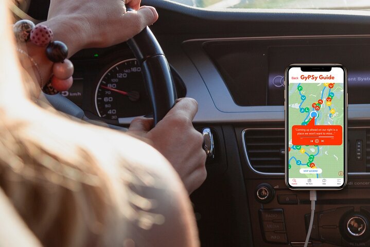
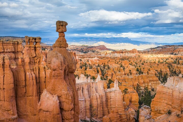
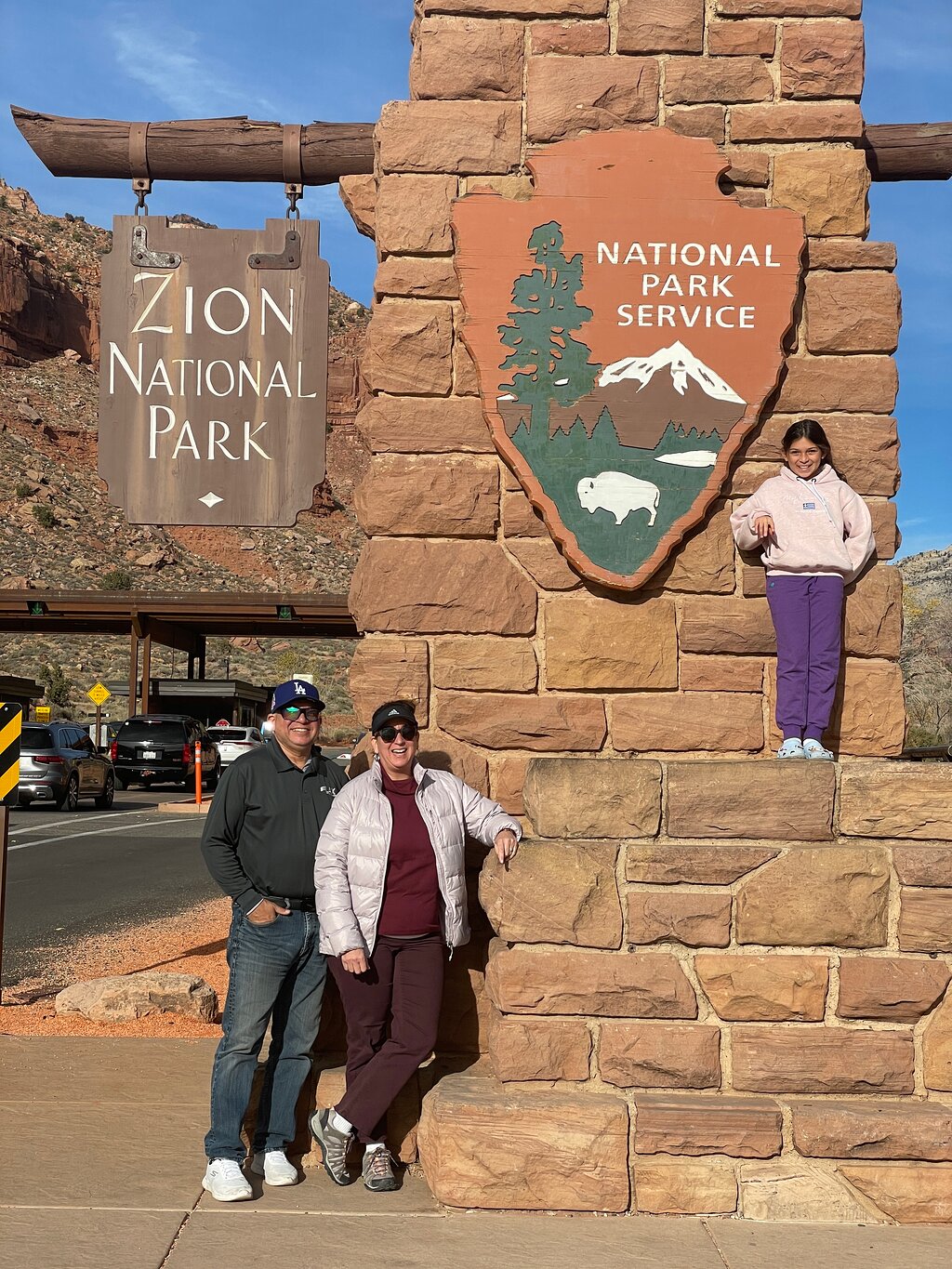
The GuideAlong Audio Driving Tour takes you on an incredible journey through two of America’s most popular national parks.

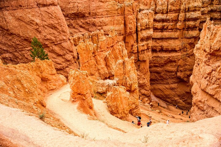
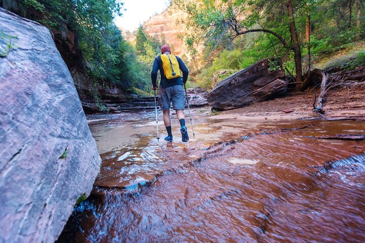
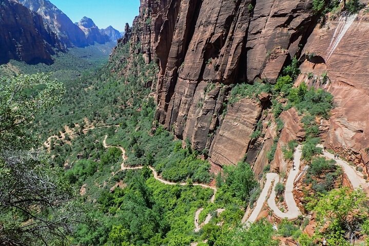
Along the way you'll be guided to all of the area's famous highlights as well as lessor known gems including bucket-list hikes, a historic ghost town, and a top lookout across the entire Bryce Amphitheater.

This self-guided audio tour helps you discover more on your road trip with fascinating behind-the-scenes stories, local tips and directions that plays automatically along the drive.

Enjoy the freedom to explore offline at your own pace so you can spend more time at places that interest you, and bypass any that don’t.

✅ Stories, tips and directions play automatically based on your location
✅ Travel at your own pace
✅ Tour offline using GPS, no cell service or WiFi needed
✅ Suggested itineraries for half, full or multi day use
✅ Buy once, use forever! No expiry, includes free updates
Цити: Национални парк Зион
Fri 18 Jul
i
Можете одабрати датум већ на веб страници за резервације
Са почетком у $17.99
Fri 18 Jul
Са почетком у $17.99
Резервисати
Шта је укључено
Слобода да истражујете сопственим темпом
Пошаљите е-пошту, ћаскајте и позовите подршку
Способност да осмислите сопствени план пута на основу вашег времена и интересовања
Савети за путовања у апликацији, савети за планирање обиласка и предложени итинерари
Аудио апликација
Приче, савети и упутства која се аутоматски репродукују на основу ваше локације
Support: Toll free phone, chat and email
Додатне информације
  • Suitable for all physical fitness levels
  • How to Access: After booking you’ll receive an email and text with instructions (search “Download Audio Tour”). Click the link in the email/text to sign in with your preferred Apple or Google account and redeem your voucher code ahead of time
  • Download The GuideAlong App: Download the free app over WiFi or cellular data and sign in with the same Apple or Google account.
  • Download The Tour: Download the tour in the GuideAlong app under 'My Tours' over WiFi or cellular data.
  • Start The Tour: Open the tour in the GuideAlong app to preview the start locations, tour route and trip planner, or start the tour.
  • Location-Based Stories: Audio commentary plays automatically as you drive using your phone’s GPS chip. Wherever you are and whichever direction you’re going, you’ll hear the best stories and tips.
  • Flexible Travel Date: Tours are a one-time purchase with no expiry or date/time limit. If your plans change to a different day, there’s no need to change your travel date.
  • Tour at Your Leisure: With GuideAlong, you control the pace. Start, stop, and resume the tour any day, anytime, adapting it to your schedule.
  • Driving Tours: Group Savings: One purchase covers everyone in the vehicle, making it a cost-effective way to explore.
  • Works Offline: No internet or cell service is required once the audio tour is downloaded to your phone, so you can relax and tour offline.
  • Works Offline: No internet or cell service is required once the audio tour is downloaded to your phone, so you can relax and tour offline.
  • Bring Earbuds/Headphones: Bring earbuds to continue listening to driving tours on park shuttles and conveniently listen to walking tours.
  • Technical Support: The GuideAlong support team is available daily by toll-free phone, online chat, and email.
Шта да очекујете
1
Национални парк Зион
Док аудио водичи пуштају коментаре на основу ваше ГПС локације, можете креирати сопствени план пута дуж руте обиласка који ће одговарати вашим интересовањима и распореду. Или можете користити наше планере путовања за наше предлоге полудневних, целодневних или вишедневних рута. Неки од многих најважнијих догађаја су наведени у наставку;
2
Национални парк Брице Цанион
Док аудио водичи пуштају коментаре на основу ваше ГПС локације, можете креирати сопствени план пута дуж руте обиласка који ће одговарати вашим интересовањима и распореду. Или можете користити наше планере путовања за наше предлоге полудневних, целодневних или вишедневних рута. Неки од многих најважнијих догађаја су наведени у наставку;
3
Инспиратион Поинт
Тачка инспирације је 3 различита погледа комбинована у један. Постоје 3 нивоа или платформе, од којих се свака пење више и отвара нове видике доле у ​​оно што се зове Тихи град. Са ове локације, посебно је лако јасно видети различите боје трака или слојева на хаудуима - у распону од беле до ружичасте до боје рђе.
4
Сунсет Поинт
На Сунсет Поинту, приближавамо се хоодооима и можемо да видимо детаље формирања и образаца ерозије. Појединачне формације имају имена попут Тхор'с Хаммер. Сунсет Поинт је стаза за једно од омиљених шетњи у Амфитеатар - Навајо Лооп Траил. Планинарење се спушта испод ивице и пешачење може да прође кроз формације као што су Волстрит и Два моста. Петља је дуга 1,3 миље, али је стаза на местима стрма.
5
Сцениц Дриве Брице Цанион
Највећа звезда Националног парка Брице Цанион је наравно Амфитеатар где посетиоци уживају у врхунским погледима на хоодоо формације. Поред амфитеатра је 18 миља Сцениц Дриве, који се наставља све до Раинбов Поинта, највише и најјужније локације у парку. Дуж прилаза постоји најмање 8 различитих извлака и видиковаца од којих сваки дели различите карактеристике Парка. Можете одабрати да се зауставите на неким или свим од њих. Наши фаворити су Раинбов Поинт, Агуа Цанион, Натурал Бридге и Фарвиев Поинт.
6
Брице Поинт
То је субјективан избор, али по нашем мишљењу ово је најбоље место за прве погледе на хоодоо, јер се налази најудаљеније и пружа најшире и величанствене погледе који обухватају огромну величину Амфитеатра. Ово је јужна крајња тачка Рим стазе. Ако желите да прошетате рубом који ће вам пружити сваки поглед, можете да се паркирате и почнете овде, а затим касније ухватите бесплатни шатл да бисте се вратили до свог возила.
7
Емералд Поолс
Смештена на Сион Цанион Сцениц Дриве, Емералд Поолс је омиљена шетња која није превише напорна, али шетачи морају бити способни да пешаче отприлике 60-90 минута неасфалтираном стазом. Први главни врхунац планинарења је Доњи смарагдни базен. Оно што је овде тако пријатно је то што заправо ходамо иза водених водопада у надвишењу налик пећини. Магла освежава и расхлађује. Иако је подложна условима стазе, а стаза је недавно оштећена и поправљена, планинари могу да одлуче да наставе даље до Средњег и Горњег базена. Наставак пешачења је напорнији од приступа Доњем базену, тако да можете одлучити да ли ћете наставити или се окренути. Стаза је преко пута Зион Натионал Парк Лодге, и то је станица за коришћење ако је на снази обавезни шатл.
8
Графтон Цеметери
Кратка и забавна диверзија на аутопуту 9 између Ла Веркина и Спрингдејла на западном улазу у Национални парк Зион, је да се кратком вожњом упутите до града духова Графтон. Можете истражити неке од старих напуштених зграда и посетити гробље ако вам то није превише језиво. Обилазак ће вам дати до знања где да скренете у малом граду Роквилу, а затим пређете на јужну страну реке Вирџин на 15 минута вожње до места града духова.
9
Цхецкербоард Меса
Можда је најпознатија и највише фотографисана знаменитост Источног Сиона Меса шаховница. Овај стенски полуконус карактеришу хоризонталне и вертикалне пукотине које му дају изглед шаховнице. За најбоље фотографије ове геолошке необичности постоји наменски извлачење и видиковац.
10
Сион-Мт. Кармелски тунел
Вожња скроз преко парка, између источног и јужног улаза, прати аутопут 9. Кратки заокрети помажу да се пут брзо попне 1000 стопа вертикалног успона. На врху тих окрета, инжењери путева нису имали куда друго да оду, па је тунел Сион-Мт Кармел створен за пролазни саобраћај. Тунел је необичан по томе што је широк само једну траку, тако да може да прими само већа возила, попут великих РВ, у једном смеру у исто време. Парк ренџери имају систем за пролазак саобраћаја кроз тунел - али можда ћете морати да будете стрпљиви за овај занимљив део вожње.
11
Спрингдале
Већина посетилаца Сиона користиће град Спрингдејл као базу за посету парку. Град се налази уз јужни улаз. Спрингдејл је град пун услуга са одличном колекцијом хотела и смештаја, ресторана и кафића. Купци ће уживати у истраживању бројних галерија. Ако планирате вожњу у Тхе Нарровс-у, у граду постоје сервисери који ће вам обезбедити сву неопходну опрему – коју је обично најбоље изнајмити.
12
Тхе Нарровс
На крају Сион Цанион Сцениц Дриве, долазимо до области где можемо уживати у шетњи поред реке, потпуно окружени величанственим вертикалним црвеним литицама Сиона. Зове се и храм Синававе. Када стигнемо до краја Риверсиде Валк-а - ту заиста почиње забава. Овде почиње Тхе Нарровс. Нема разлога да престанете да ходате само зато што сте стигли до реке Девице, одакле је сама река постала стаза. Планинари користе реку да наставе да прате кањон, док се зидови затварају и постају још импозантнији. Вода је обично хладна, тако да за Нарровс носите опрему за гажење, ципеле за кањоне за боље приањање док ходате кроз реку и врећу за сушење да чувате своје драгоцености. Чврста мотка за ходање не само да употпуни изглед, већ вам помаже да се стабилизујете док ходате. Већина просечних планинара ће прећи 3-4 миље пре него што се врате назад. Већину времена вода је дубока само до глежња, али на неким местима може доћи до струка.
13
Веепинг Роцк Траил
Ово је одлична станица дуж пута Зион Сцениц Дриве. Само кратка шетња узбрдо од 1/4 миље води вас до љупке висеће баште, а ово је још једна локација на којој ћете бити на "унутрашњости" финог водопада. Дефинитивно вреди 30-ак минута колико је потребно за уживање у искуству. Постоје још 2 популарне шетње које захтевају много више труда које крећу са ове локације. Скривени кањон је кружно путовање од 5 миља до скривеног кањона - није изненађење. Планинарење је прилично изложено и обезбеђени су гвоздени ланци који ће вам на неким местима помоћи да останете на стази. Одавде полази и најтежа дневна пешачење у парку, пешачење на Обсерватион Поинт-у дужине 8 миља пење се до врха планине - уздиже се 2150 вертикалних стопа. То је добра вежба!
14
Црвени кањон
Аутопут 12 спаја Национални парк Брајс кањон са аутопутем 89, који је главна рута која повезује Сион и Брајс. 12. проћи ћемо Црвени кањон. Имате избор да се придружите неким занимљивим шетњама овде, али за већину путника, врхунац је да се зауставе и фотографишу два кратка тунела која су урезана кроз стеновите пераје које омогућавају да аутопут прође.
15
Гротто Траил
Стаза Гротто је лагана равна шетња у којој многи људи уживају као начин да протегну ноге и приступе Зион Лодгеу. Али ова локација је далеко познатија као полазна тачка за изазовно планинарење Ангел'с Ландинг. Тај поход се препоручује само искусним и припремљеним планинарима који се осећају пријатно на висини. Најизазовнији део - ментално, је прелазак уске платформе, 1.500 стопа изнад дна долине. Укупна дужина пешачења је 5 миља и захтева значајно повећање надморске висине. Толико је популаран да на стази понекад може бити права гужва.
16
Сунрисе Поинт
Ово је видиковац за Амфитеатар који је најближи улазу у Брице Цанион. Још једном, можемо да уживамо у погледу изблиза на несигурно избалансиране торњеве и формације које изгледају спремне да одустану и сруше се. Они који желе да пешаче у Амфитеатар придружиће се стази Куеенс Гарден. Ово пешачење се може обавити као стаза напољу и назад у дужини од 2,8 миље, или се може комбиновати са стазом Навајо Лооп до краја на Сунсет Поинту. Постоји безброј невероватних формација у којима ћете уживати током пешачења, а пожелећете да се зауставите и фотографишете на неким од вилинских врата која вас воде право кроз неке формације. Стаза је добила име по одређеном хоодоо-у који изгледа као краљица Викторија - то није претеривање!
17
Zion National Park
As the audio guides play commentary based on your gps location, you can create your own itinerary along the tour route to match your interests and schedule. Or you can use our trip planners for our suggestions on half, full or multi day itineraries. Some of the many highlights are listed below;
18
Bryce Canyon National Park
As the audio guides play commentary based on your gps location, you can create your own itinerary along the tour route to match your interests and schedule. Or you can use our trip planners for our suggestions on half, full or multi day itineraries. Some of the many highlights are listed below;
19
Inspiration Point
Inspiration Point is 3 different views combined into one. There are 3 tiers or platforms, each one climbing higher and opening new vistas down into what is called the Silent City. From this location, it's especially easy to clearly see the different colors of the bands or stratas in the hoodoos - ranging from white to pink to rust colored.
20
Sunset Point
At Sunset Point, we are getting quite close to the hoodoos and can see details of the formation and erosion patterns. Individual formations have names like Thor's Hammer. Sunset Point is the trailhead for one of the favorite hikes into the Amphitheater - the Navajo Loop Trail. The hike descends down below the rim and hikes can walk through formations like Wall Street and Two Bridges. The loop is 1.3 miles, but the trail is steep in places.
21
Bryce Canyon Scenic Drive
The greatest star of the Bryce Canyon National Park is of course the Amphitheater where visitors enjoy superb views of the hoodoo formations. Past the Amphitheater is the 18-mile Scenic Drive, which continues all the way to Rainbow Point, the highest and southernmost location in the park. Along the drive there are at least 8 different pullouts and viewpoints that each share a different feature of the Park. You can choose to stop at some or all of them. Our favorites are Rainbow Point, Agua Canyon, Natural Bridge and Farview Point.
22
Bryce Point
It's a subjective choice, but in our opinion this is the best place to take in your first views of the hoodoos, as it is located the furtherest away and provides the widest and grand views that captures the enormity of the Amphitheater. This is the southern end point of the Rim Trail. If you want to walk the rim which will provide you with every view, you can park and start here, and then later catch the free shuttle to get back to your vehicle.
23
Emerald Pools
Located on the Zion Canyon Scenic Drive, Emerald Pools is a favourite hike that is not too strenuous, but walkers need to be capable of hiking roughly 60-90 minutes on an unpaved trail. The first major highlight of the hike is the Lower Emerald Pool. What is so enjoyable here is that we actually walk behind the spray of the waterfalls in a cave-like overhang. The mist is refreshing and cooling. Though subject to trail conditions, and the trail has been recently damaged and repaired, hikers can choose to continue on to the Middle and Upper Pools. The continuation of the hike is more strenuous than accessing the Lower Pool, so you can decide whether to continue or turn around. The trailhead is opposite Zion National Park Lodge, and that is the stop to use if the mandatory shuttle is in effect.
24
Grafton Cemetary
A short and fun diversion on Highway 9 between La Verkin and Springdale at the western entrance to Zion National Park, is to take the short drive to the Grafton Ghost Town. You can explore some of the old abandoned buildings, and visit the cemetery if you don't find that too creepy. The tour will let you know where to turn off in the small town of Rockville, and then cross to the southside of the Virgin River for the 15 minute drive to the ghost town site.
25
Checkerboard Mesa
Perhaps the best-known and most photographed landmark in East Zion is the Checkerboard Mesa. This rock half-cone is characterized by horizontal and vertical cracks that give it that checkerboard appearance. There is a dedicated pullout and viewpoint for the best photos of this geological oddity.
26
Zion-Mt. Carmel Tunnel
Driving all the way across the park, between the East and South Entrances, follows Highway 9. Short switchbacks help the road quickly climb 1000 feet of vertical rise. At the top of those switchbacks, road engineers had nowhere else to go, and so the Zion-Mt Carmel Tunnel was created for through traffic. The tunnel is unusual in that it is only one lane wide, so it can only accommodate larger vehicles, like large RVs, in one direction at a time. Park Rangers have a system to get traffic through the tunnel - but you may need to exercise patience for this interesting part of the drive.
27
Springdale
Most visitors to Zion will use the town of Springdale as their base for visiting the park. The town is located adjacent to the south entrance. Springdale is a full-service town with an excellent collection of hotels and accommodations, restaurants and cafes. Shoppers will enjoy the exploring the many galleries. If you are planning the wade in The Narrows, there are outfitters in town that will set you up with all the necessary gear - which is usually best to rent.
28
The Narrows
At the end of the Zion Canyon Scenic Drive, we come to an area where we can enjoy the riverside walk, completely surrounded by Zion's magnificent vertical red rock cliffs. It's also called the Temple of Sinawava. Once we reach the end of the Riverside Walk - that's where the fun really starts. This is where The Narrows begins. There's no reason to stop walking just because you've reached the Virgin River, from here the river itself become the trail. Hikers use the river to continue following the canyon, as the walls close in and become even more imposing. The water tends to be chilly, so to do the Narrows, you wear wading gear, canyoneering shoes for better grip as you walk through the river, and a drysack to keep your valuables safe. And a sturdy walking pole is not just to complete the look, but helps stabilize you as you wade. Most average hikers will go 3-4 miles before turning back. Most of the time the water is only ankle deep, but it can get waist deep in some places.
29
Weeping Rock Trail
This is a great stop along the Zion Scenic Drive Road. Just a short 1/4 mile uphill walk gets you to a lovely hanging garden and this is another location where you will be on the "inside" of a fine waterfall. Its definitely worth the 30 minutes or so that it takes to enjoy the experience. There are 2 other popular hikes that require much more effort that depart from this location. Hidden Canyon is a 5-mile round trip to a hidden canyon - no surprise. The hike is quite exposed and iron chains are provided to help you stay on the trail in places. The toughest day hike in the Park also leaves from here, the 8-mile Observation Point hike climbs to the top of the mesa - rising 2150 vertical feet. Its a good workout!
30
Red Canyon
Highway 12 joins Bryce Canyon National Park to Highway 89, which is the main route to connect Zion and Bryce. On 12, we will pass the Red Canyon. You have the choice to join some interesting hikes here, but for most road trippers, the highlight is to stop and take photos of two short tunnels that have been carved through rock fins that allow the highway to pass through.
31
Grotto Trail
The Grotto Trail is an easy flat walk that many people enjoy as a way to stretch their legs and access the Zion Lodge. But this location is far more famous as the starting point for the challenging Angel's Landing hike. That hike is only recommended for experienced and prepared hikers who are comfortable with heights. The most challenging section - mentally, is the crossing of a narrow ledge, 1,500 feet above the valley floor. The hike overall is 5-miles and requires significant elevation gain. It is so popular, that the trail can be downright crowded at times.
32
Sunrise Point
This is the viewpoint for the Amphitheater that is closest to the entrance for Bryce Canyon. Once again, we get to enjoy close up views of precariously balanced spires and formations that look ready to give up and collapse. Those who want to hike into the Amphitheater will join the the Queens Garden Trail. This hike can be done as an out-and-back trail for 1.8 miles, or can be combined with the Navajo Loop trail to finish at Sunset Point. There are countless amazing formations that you will enjoy on the hike, and you will want to stop for photos at some of the fairy-like doorways that take you right through some formations. The trail gets its name from a particular hoodoo that looks like Queen Victoria - that's no exaggeration!
33
Zion National Park
As the audio guides play commentary based on your gps location, you can create your own itinerary along the tour route to match your interests and schedule. Or you can use our trip planners for our suggestions on half, full or multi day itineraries. Some of the many highlights are listed below;
34
Bryce Canyon National Park
As the audio guides play commentary based on your gps location, you can create your own itinerary along the tour route to match your interests and schedule. Or you can use our trip planners for our suggestions on half, full or multi day itineraries. Some of the many highlights are listed below;
35
Inspiration Point
Inspiration Point is 3 different views combined into one. There are 3 tiers or platforms, each one climbing higher and opening new vistas down into what is called the Silent City. From this location, it's especially easy to clearly see the different colors of the bands or stratas in the hoodoos - ranging from white to pink to rust colored.
36
Sunset Point
At Sunset Point, we are getting quite close to the hoodoos and can see details of the formation and erosion patterns. Individual formations have names like Thor's Hammer. Sunset Point is the trailhead for one of the favorite hikes into the Amphitheater - the Navajo Loop Trail. The hike descends down below the rim and hikes can walk through formations like Wall Street and Two Bridges. The loop is 1.3 miles, but the trail is steep in places.
37
Bryce Canyon Scenic Drive
The greatest star of the Bryce Canyon National Park is of course the Amphitheater where visitors enjoy superb views of the hoodoo formations. Past the Amphitheater is the 18-mile Scenic Drive, which continues all the way to Rainbow Point, the highest and southernmost location in the park. Along the drive there are at least 8 different pullouts and viewpoints that each share a different feature of the Park. You can choose to stop at some or all of them. Our favorites are Rainbow Point, Agua Canyon, Natural Bridge and Farview Point.
38
Bryce Point
It's a subjective choice, but in our opinion this is the best place to take in your first views of the hoodoos, as it is located the furtherest away and provides the widest and grand views that captures the enormity of the Amphitheater. This is the southern end point of the Rim Trail. If you want to walk the rim which will provide you with every view, you can park and start here, and then later catch the free shuttle to get back to your vehicle.
39
Emerald Pools
Located on the Zion Canyon Scenic Drive, Emerald Pools is a favourite hike that is not too strenuous, but walkers need to be capable of hiking roughly 60-90 minutes on an unpaved trail. The first major highlight of the hike is the Lower Emerald Pool. What is so enjoyable here is that we actually walk behind the spray of the waterfalls in a cave-like overhang. The mist is refreshing and cooling. Though subject to trail conditions, and the trail has been recently damaged and repaired, hikers can choose to continue on to the Middle and Upper Pools. The continuation of the hike is more strenuous than accessing the Lower Pool, so you can decide whether to continue or turn around. The trailhead is opposite Zion National Park Lodge, and that is the stop to use if the mandatory shuttle is in effect.
40
Grafton Cemetary
A short and fun diversion on Highway 9 between La Verkin and Springdale at the western entrance to Zion National Park, is to take the short drive to the Grafton Ghost Town. You can explore some of the old abandoned buildings, and visit the cemetery if you don't find that too creepy. The tour will let you know where to turn off in the small town of Rockville, and then cross to the southside of the Virgin River for the 15 minute drive to the ghost town site.
41
Checkerboard Mesa
Perhaps the best-known and most photographed landmark in East Zion is the Checkerboard Mesa. This rock half-cone is characterized by horizontal and vertical cracks that give it that checkerboard appearance. There is a dedicated pullout and viewpoint for the best photos of this geological oddity.
42
Zion-Mt. Carmel Tunnel
Driving all the way across the park, between the East and South Entrances, follows Highway 9. Short switchbacks help the road quickly climb 1000 feet of vertical rise. At the top of those switchbacks, road engineers had nowhere else to go, and so the Zion-Mt Carmel Tunnel was created for through traffic. The tunnel is unusual in that it is only one lane wide, so it can only accommodate larger vehicles, like large RVs, in one direction at a time. Park Rangers have a system to get traffic through the tunnel - but you may need to exercise patience for this interesting part of the drive.
43
Springdale
Most visitors to Zion will use the town of Springdale as their base for visiting the park. The town is located adjacent to the south entrance. Springdale is a full-service town with an excellent collection of hotels and accommodations, restaurants and cafes. Shoppers will enjoy the exploring the many galleries. If you are planning the wade in The Narrows, there are outfitters in town that will set you up with all the necessary gear - which is usually best to rent.
44
The Narrows
At the end of the Zion Canyon Scenic Drive, we come to an area where we can enjoy the riverside walk, completely surrounded by Zion's magnificent vertical red rock cliffs. It's also called the Temple of Sinawava. Once we reach the end of the Riverside Walk - that's where the fun really starts. This is where The Narrows begins. There's no reason to stop walking just because you've reached the Virgin River, from here the river itself become the trail. Hikers use the river to continue following the canyon, as the walls close in and become even more imposing. The water tends to be chilly, so to do the Narrows, you wear wading gear, canyoneering shoes for better grip as you walk through the river, and a drysack to keep your valuables safe. And a sturdy walking pole is not just to complete the look, but helps stabilize you as you wade. Most average hikers will go 3-4 miles before turning back. Most of the time the water is only ankle deep, but it can get waist deep in some places.
45
Weeping Rock Trail
This is a great stop along the Zion Scenic Drive Road. Just a short 1/4 mile uphill walk gets you to a lovely hanging garden and this is another location where you will be on the "inside" of a fine waterfall. Its definitely worth the 30 minutes or so that it takes to enjoy the experience. There are 2 other popular hikes that require much more effort that depart from this location. Hidden Canyon is a 5-mile round trip to a hidden canyon - no surprise. The hike is quite exposed and iron chains are provided to help you stay on the trail in places. The toughest day hike in the Park also leaves from here, the 8-mile Observation Point hike climbs to the top of the mesa - rising 2150 vertical feet. Its a good workout!
46
Red Canyon
Highway 12 joins Bryce Canyon National Park to Highway 89, which is the main route to connect Zion and Bryce. On 12, we will pass the Red Canyon. You have the choice to join some interesting hikes here, but for most road trippers, the highlight is to stop and take photos of two short tunnels that have been carved through rock fins that allow the highway to pass through.
47
Grotto Trail
The Grotto Trail is an easy flat walk that many people enjoy as a way to stretch their legs and access the Zion Lodge. But this location is far more famous as the starting point for the challenging Angel's Landing hike. That hike is only recommended for experienced and prepared hikers who are comfortable with heights. The most challenging section - mentally, is the crossing of a narrow ledge, 1,500 feet above the valley floor. The hike overall is 5-miles and requires significant elevation gain. It is so popular, that the trail can be downright crowded at times.
48
Sunrise Point
This is the viewpoint for the Amphitheater that is closest to the entrance for Bryce Canyon. Once again, we get to enjoy close up views of precariously balanced spires and formations that look ready to give up and collapse. Those who want to hike into the Amphitheater will join the the Queens Garden Trail. This hike can be done as an out-and-back trail for 1.8 miles, or can be combined with the Navajo Loop trail to finish at Sunset Point. There are countless amazing formations that you will enjoy on the hike, and you will want to stop for photos at some of the fairy-like doorways that take you right through some formations. The trail gets its name from a particular hoodoo that looks like Queen Victoria - that's no exaggeration!
49
Zion National Park
As the audio guides play commentary based on your gps location, you can create your own itinerary along the tour route to match your interests and schedule. Or you can use our trip planners for our suggestions on half, full or multi day itineraries. Some of the many highlights are listed below;
50
Bryce Canyon National Park
As the audio guides play commentary based on your gps location, you can create your own itinerary along the tour route to match your interests and schedule. Or you can use our trip planners for our suggestions on half, full or multi day itineraries. Some of the many highlights are listed below;
51
Inspiration Point
Inspiration Point is 3 different views combined into one. There are 3 tiers or platforms, each one climbing higher and opening new vistas down into what is called the Silent City. From this location, it's especially easy to clearly see the different colors of the bands or stratas in the hoodoos - ranging from white to pink to rust colored.
52
Sunset Point
At Sunset Point, we are getting quite close to the hoodoos and can see details of the formation and erosion patterns. Individual formations have names like Thor's Hammer. Sunset Point is the trailhead for one of the favorite hikes into the Amphitheater - the Navajo Loop Trail. The hike descends down below the rim and hikes can walk through formations like Wall Street and Two Bridges. The loop is 1.3 miles, but the trail is steep in places.
53
Bryce Canyon Scenic Drive
The greatest star of the Bryce Canyon National Park is of course the Amphitheater where visitors enjoy superb views of the hoodoo formations. Past the Amphitheater is the 18-mile Scenic Drive, which continues all the way to Rainbow Point, the highest and southernmost location in the park. Along the drive there are at least 8 different pullouts and viewpoints that each share a different feature of the Park. You can choose to stop at some or all of them. Our favorites are Rainbow Point, Agua Canyon, Natural Bridge and Farview Point.
54
Bryce Point
It's a subjective choice, but in our opinion this is the best place to take in your first views of the hoodoos, as it is located the furtherest away and provides the widest and grand views that captures the enormity of the Amphitheater. This is the southern end point of the Rim Trail. If you want to walk the rim which will provide you with every view, you can park and start here, and then later catch the free shuttle to get back to your vehicle.
55
Emerald Pools
Located on the Zion Canyon Scenic Drive, Emerald Pools is a favourite hike that is not too strenuous, but walkers need to be capable of hiking roughly 60-90 minutes on an unpaved trail. The first major highlight of the hike is the Lower Emerald Pool. What is so enjoyable here is that we actually walk behind the spray of the waterfalls in a cave-like overhang. The mist is refreshing and cooling. Though subject to trail conditions, and the trail has been recently damaged and repaired, hikers can choose to continue on to the Middle and Upper Pools. The continuation of the hike is more strenuous than accessing the Lower Pool, so you can decide whether to continue or turn around. The trailhead is opposite Zion National Park Lodge, and that is the stop to use if the mandatory shuttle is in effect.
56
Grafton Cemetary
A short and fun diversion on Highway 9 between La Verkin and Springdale at the western entrance to Zion National Park, is to take the short drive to the Grafton Ghost Town. You can explore some of the old abandoned buildings, and visit the cemetery if you don't find that too creepy. The tour will let you know where to turn off in the small town of Rockville, and then cross to the southside of the Virgin River for the 15 minute drive to the ghost town site.
57
Checkerboard Mesa
Perhaps the best-known and most photographed landmark in East Zion is the Checkerboard Mesa. This rock half-cone is characterized by horizontal and vertical cracks that give it that checkerboard appearance. There is a dedicated pullout and viewpoint for the best photos of this geological oddity.
58
Zion-Mt. Carmel Tunnel
Driving all the way across the park, between the East and South Entrances, follows Highway 9. Short switchbacks help the road quickly climb 1000 feet of vertical rise. At the top of those switchbacks, road engineers had nowhere else to go, and so the Zion-Mt Carmel Tunnel was created for through traffic. The tunnel is unusual in that it is only one lane wide, so it can only accommodate larger vehicles, like large RVs, in one direction at a time. Park Rangers have a system to get traffic through the tunnel - but you may need to exercise patience for this interesting part of the drive.
59
Springdale
Most visitors to Zion will use the town of Springdale as their base for visiting the park. The town is located adjacent to the south entrance. Springdale is a full-service town with an excellent collection of hotels and accommodations, restaurants and cafes. Shoppers will enjoy the exploring the many galleries. If you are planning the wade in The Narrows, there are outfitters in town that will set you up with all the necessary gear - which is usually best to rent.
60
The Narrows
At the end of the Zion Canyon Scenic Drive, we come to an area where we can enjoy the riverside walk, completely surrounded by Zion's magnificent vertical red rock cliffs. It's also called the Temple of Sinawava. Once we reach the end of the Riverside Walk - that's where the fun really starts. This is where The Narrows begins. There's no reason to stop walking just because you've reached the Virgin River, from here the river itself become the trail. Hikers use the river to continue following the canyon, as the walls close in and become even more imposing. The water tends to be chilly, so to do the Narrows, you wear wading gear, canyoneering shoes for better grip as you walk through the river, and a drysack to keep your valuables safe. And a sturdy walking pole is not just to complete the look, but helps stabilize you as you wade. Most average hikers will go 3-4 miles before turning back. Most of the time the water is only ankle deep, but it can get waist deep in some places.
61
Weeping Rock Trail
This is a great stop along the Zion Scenic Drive Road. Just a short 1/4 mile uphill walk gets you to a lovely hanging garden and this is another location where you will be on the "inside" of a fine waterfall. Its definitely worth the 30 minutes or so that it takes to enjoy the experience. There are 2 other popular hikes that require much more effort that depart from this location. Hidden Canyon is a 5-mile round trip to a hidden canyon - no surprise. The hike is quite exposed and iron chains are provided to help you stay on the trail in places. The toughest day hike in the Park also leaves from here, the 8-mile Observation Point hike climbs to the top of the mesa - rising 2150 vertical feet. Its a good workout!
62
Red Canyon
Highway 12 joins Bryce Canyon National Park to Highway 89, which is the main route to connect Zion and Bryce. On 12, we will pass the Red Canyon. You have the choice to join some interesting hikes here, but for most road trippers, the highlight is to stop and take photos of two short tunnels that have been carved through rock fins that allow the highway to pass through.
63
Grotto Trail
The Grotto Trail is an easy flat walk that many people enjoy as a way to stretch their legs and access the Zion Lodge. But this location is far more famous as the starting point for the challenging Angel's Landing hike. That hike is only recommended for experienced and prepared hikers who are comfortable with heights. The most challenging section - mentally, is the crossing of a narrow ledge, 1,500 feet above the valley floor. The hike overall is 5-miles and requires significant elevation gain. It is so popular, that the trail can be downright crowded at times.
64
Sunrise Point
This is the viewpoint for the Amphitheater that is closest to the entrance for Bryce Canyon. Once again, we get to enjoy close up views of precariously balanced spires and formations that look ready to give up and collapse. Those who want to hike into the Amphitheater will join the the Queens Garden Trail. This hike can be done as an out-and-back trail for 1.8 miles, or can be combined with the Navajo Loop trail to finish at Sunset Point. There are countless amazing formations that you will enjoy on the hike, and you will want to stop for photos at some of the fairy-like doorways that take you right through some formations. The trail gets its name from a particular hoodoo that looks like Queen Victoria - that's no exaggeration!
65
Zion National Park
As the audio guides play commentary based on your gps location, you can create your own itinerary along the tour route to match your interests and schedule. Or you can use our trip planners for our suggestions on half, full or multi day itineraries. Some of the many highlights are listed below;
66
Bryce Canyon National Park
As the audio guides play commentary based on your gps location, you can create your own itinerary along the tour route to match your interests and schedule. Or you can use our trip planners for our suggestions on half, full or multi day itineraries. Some of the many highlights are listed below;
67
Inspiration Point
Inspiration Point is 3 different views combined into one. There are 3 tiers or platforms, each one climbing higher and opening new vistas down into what is called the Silent City. From this location, it's especially easy to clearly see the different colors of the bands or stratas in the hoodoos - ranging from white to pink to rust colored.
68
Sunset Point
At Sunset Point, we are getting quite close to the hoodoos and can see details of the formation and erosion patterns. Individual formations have names like Thor's Hammer. Sunset Point is the trailhead for one of the favorite hikes into the Amphitheater - the Navajo Loop Trail. The hike descends down below the rim and hikes can walk through formations like Wall Street and Two Bridges. The loop is 1.3 miles, but the trail is steep in places.
69
Bryce Canyon Scenic Drive
The greatest star of the Bryce Canyon National Park is of course the Amphitheater where visitors enjoy superb views of the hoodoo formations. Past the Amphitheater is the 18-mile Scenic Drive, which continues all the way to Rainbow Point, the highest and southernmost location in the park. Along the drive there are at least 8 different pullouts and viewpoints that each share a different feature of the Park. You can choose to stop at some or all of them. Our favorites are Rainbow Point, Agua Canyon, Natural Bridge and Farview Point.
70
Bryce Point
It's a subjective choice, but in our opinion this is the best place to take in your first views of the hoodoos, as it is located the furtherest away and provides the widest and grand views that captures the enormity of the Amphitheater. This is the southern end point of the Rim Trail. If you want to walk the rim which will provide you with every view, you can park and start here, and then later catch the free shuttle to get back to your vehicle.
71
Emerald Pools
Located on the Zion Canyon Scenic Drive, Emerald Pools is a favourite hike that is not too strenuous, but walkers need to be capable of hiking roughly 60-90 minutes on an unpaved trail. The first major highlight of the hike is the Lower Emerald Pool. What is so enjoyable here is that we actually walk behind the spray of the waterfalls in a cave-like overhang. The mist is refreshing and cooling. Though subject to trail conditions, and the trail has been recently damaged and repaired, hikers can choose to continue on to the Middle and Upper Pools. The continuation of the hike is more strenuous than accessing the Lower Pool, so you can decide whether to continue or turn around. The trailhead is opposite Zion National Park Lodge, and that is the stop to use if the mandatory shuttle is in effect.
72
Grafton Cemetary
A short and fun diversion on Highway 9 between La Verkin and Springdale at the western entrance to Zion National Park, is to take the short drive to the Grafton Ghost Town. You can explore some of the old abandoned buildings, and visit the cemetery if you don't find that too creepy. The tour will let you know where to turn off in the small town of Rockville, and then cross to the southside of the Virgin River for the 15 minute drive to the ghost town site.
73
Checkerboard Mesa
Perhaps the best-known and most photographed landmark in East Zion is the Checkerboard Mesa. This rock half-cone is characterized by horizontal and vertical cracks that give it that checkerboard appearance. There is a dedicated pullout and viewpoint for the best photos of this geological oddity.
74
Zion-Mt. Carmel Tunnel
Driving all the way across the park, between the East and South Entrances, follows Highway 9. Short switchbacks help the road quickly climb 1000 feet of vertical rise. At the top of those switchbacks, road engineers had nowhere else to go, and so the Zion-Mt Carmel Tunnel was created for through traffic. The tunnel is unusual in that it is only one lane wide, so it can only accommodate larger vehicles, like large RVs, in one direction at a time. Park Rangers have a system to get traffic through the tunnel - but you may need to exercise patience for this interesting part of the drive.
75
Springdale
Most visitors to Zion will use the town of Springdale as their base for visiting the park. The town is located adjacent to the south entrance. Springdale is a full-service town with an excellent collection of hotels and accommodations, restaurants and cafes. Shoppers will enjoy the exploring the many galleries. If you are planning the wade in The Narrows, there are outfitters in town that will set you up with all the necessary gear - which is usually best to rent.
76
The Narrows
At the end of the Zion Canyon Scenic Drive, we come to an area where we can enjoy the riverside walk, completely surrounded by Zion's magnificent vertical red rock cliffs. It's also called the Temple of Sinawava. Once we reach the end of the Riverside Walk - that's where the fun really starts. This is where The Narrows begins. There's no reason to stop walking just because you've reached the Virgin River, from here the river itself become the trail. Hikers use the river to continue following the canyon, as the walls close in and become even more imposing. The water tends to be chilly, so to do the Narrows, you wear wading gear, canyoneering shoes for better grip as you walk through the river, and a drysack to keep your valuables safe. And a sturdy walking pole is not just to complete the look, but helps stabilize you as you wade. Most average hikers will go 3-4 miles before turning back. Most of the time the water is only ankle deep, but it can get waist deep in some places.
77
Weeping Rock Trail
This is a great stop along the Zion Scenic Drive Road. Just a short 1/4 mile uphill walk gets you to a lovely hanging garden and this is another location where you will be on the "inside" of a fine waterfall. Its definitely worth the 30 minutes or so that it takes to enjoy the experience. There are 2 other popular hikes that require much more effort that depart from this location. Hidden Canyon is a 5-mile round trip to a hidden canyon - no surprise. The hike is quite exposed and iron chains are provided to help you stay on the trail in places. The toughest day hike in the Park also leaves from here, the 8-mile Observation Point hike climbs to the top of the mesa - rising 2150 vertical feet. Its a good workout!
78
Red Canyon
Highway 12 joins Bryce Canyon National Park to Highway 89, which is the main route to connect Zion and Bryce. On 12, we will pass the Red Canyon. You have the choice to join some interesting hikes here, but for most road trippers, the highlight is to stop and take photos of two short tunnels that have been carved through rock fins that allow the highway to pass through.
79
Grotto Trail
The Grotto Trail is an easy flat walk that many people enjoy as a way to stretch their legs and access the Zion Lodge. But this location is far more famous as the starting point for the challenging Angel's Landing hike. That hike is only recommended for experienced and prepared hikers who are comfortable with heights. The most challenging section - mentally, is the crossing of a narrow ledge, 1,500 feet above the valley floor. The hike overall is 5-miles and requires significant elevation gain. It is so popular, that the trail can be downright crowded at times.
80
Sunrise Point
This is the viewpoint for the Amphitheater that is closest to the entrance for Bryce Canyon. Once again, we get to enjoy close up views of precariously balanced spires and formations that look ready to give up and collapse. Those who want to hike into the Amphitheater will join the the Queens Garden Trail. This hike can be done as an out-and-back trail for 1.8 miles, or can be combined with the Navajo Loop trail to finish at Sunset Point. There are countless amazing formations that you will enjoy on the hike, and you will want to stop for photos at some of the fairy-like doorways that take you right through some formations. The trail gets its name from a particular hoodoo that looks like Queen Victoria - that's no exaggeration!
Show 77 више заустављања
Политика отказивања
For a full refund, cancel at least 24 hours before the scheduled departure time.
Фотографије путника
Коментара (10)
Stacey_H
Jan 2025
The drive-through Bryce was amazing! I loved how the tour told us exactly where to go and what we could see or skip.
Одговор домаћина
Jan 2025
Hi Stacey; thank you for sharing your experience. We're thrilled you enjoyed the drive through Bryce and found the tour helpful in guiding you to the best stops. It’s great to hear the tour added value to your trip. We hope to join you on the road again soon!
Alicia_L
Dec 2024
Highly recommend this tour if you are driving through the park. The guide was so helpful in explaining sites we were driving past.
Одговор домаћина
Dec 2024
Hi Alicia, thank you for your wonderful feedback. We're thrilled to hear the tour enhanced your drive through Zion, offering helpful insights about the sites you passed. Your recommendation means a lot to us. We hope to join you on the road again soon!
Shsree_K
Nov 2024
We loved the app but it was a little difficult to access after we purchased it. The guiding wa great though
Одговор домаћина
Nov 2024
Hi there; thank you for sharing your experience. We're glad to hear you loved the guiding aspects of the tour. We appreciate your patience with the initial setup and are here to help if you need assistance in the future. We hope to join you on the road again soon!

Повезани догађаји

Догађаји у истој области

Мислимо да је ваш језик English
На ком језику желите да видите ову страницу?
English English
Мислимо да је ваш град Нев Иорк Цити
У ком граду бисте тражили истраживање?
Нев Иорк Цити
New York City